File:NASA's AIRS Instrument Tracks Transport of Sulfur Dioxide from Chilean Volcanic Eruption (Animation).ogv
NASA's_AIRS_Instrument_Tracks_Transport_of_Sulfur_Dioxide_from_Chilean_Volcanic_Eruption_(Animation).ogv (Ogg Theora video file, length 26 s, 740 × 458 pixels, 517 kbps, file size: 1.6 MB)
Captions
Captions
Summary
[edit]| Description |
English: NASA's AIRS Instrument Tracks Transport of Sulfur Dioxide from Chilean Volcanic Eruption (Animation)
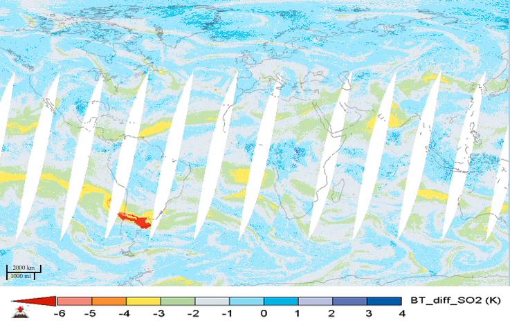
For the first time in 40 years, the Calbuco volcano in southern Chile erupted on April 22, 2015. The eruption caused airline flight cancellations in Chile, Argentina and Uruguay and the evacuation of approximately 4,000 people. This movie shows alternating day and nighttime views of the plume of sulfur dioxide gas emitted by Calbuco, as observed by NASA's Atmospheric Infrared Sounder (AIRS) instrument on NASA's Aqua spacecraft, from April 22 to May 5, 2015. Significant amounts of sulfur dioxide are shown in bright red. The largest plume is apparent over South America during the initial eruption on April 22. The plume is then carried by winds across the south Atlantic Ocean and southern Africa. A second large eruption on April 29 produced a smaller plume. Volcanic sulfur dioxide can be an important factor in climate. Some of it is carried into Earth's stratosphere, where it is transformed into highly reflective droplets of sulfuric acid. By reflecting sunlight, these droplets can cool Earth. Large eruptions, like Mt. Pinatubo in 1991, cool our planet and disrupt rainfall patterns. Though an impressive eruption, Calbuco is expected to have only a small impact on Earth's climate. AIRS sulfur dioxide data are used to alert the air transportation industry about volcanic eruptions. Combined with measurements of volcanic ash, they provide a long-term record of the effects of volcanoes on the atmosphere. AIRS Near-Real Time (NRT) processing and imagery are provided by a collaborative effort between NASA's Goddard Earth Science Data and Information Services Center (GES DISC), and the AIRS Team at NASA's Jet Propulsion Laboratory, Pasadena, California. AIRS NRT is an element of the Land, Atmosphere Near real-time Capability for NASA's Earth Observing System (LANCE). More information on LANCE is available at About AIRS More information about AIRS can be found at Image Details Mission: Aqua Target: Earth Spacecraft: Aqua Instrument: Atmospheric Infrared Sounder (AIRS) Full-Res TIFF: PIA19385.tif (1.03 MB) Full-Res JPG: PIA19385.jpg (0.07 MB) Image credit: NASA/JPL-Caltech Wallpaper Applying Wallpaper: Fullscreen download sizes: 1280 x 800 1440 x 900 1920 x 1200 |
| Date | April 22 to May 5, 2015 |
| Source | http://www.jpl.nasa.gov/spaceimages/details.php?id=pia19385 |
| Author | NASA |
Licensing
[edit]| This file is in the public domain in the United States because it was solely created by NASA. NASA copyright policy states that "NASA material is not protected by copyright unless noted". (See Template:PD-USGov, NASA copyright policy page or JPL Image Use Policy.) | ||
 |
Warnings:
|
File history
Click on a date/time to view the file as it appeared at that time.
| Date/Time | Thumbnail | Dimensions | User | Comment | |
|---|---|---|---|---|---|
| current | 17:33, 7 June 2015 | 26 s, 740 × 458 (1.6 MB) | LuisArmandoRasteletti (talk | contribs) | User created page with UploadWizard |
You cannot overwrite this file.
File usage on Commons
There are no pages that use this file.