File:Mysterious bell-towered ruin - geograph.org.uk - 377995.jpg
Jump to navigation
Jump to search
No higher resolution available.
Mysterious_bell-towered_ruin_-_geograph.org.uk_-_377995.jpg (640 × 480 pixels, file size: 81 KB, MIME type: image/jpeg)
Captions
Captions
Add a one-line explanation of what this file represents
Summary
[edit]
| Description |
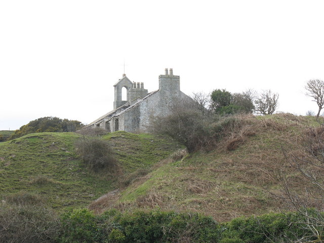
English: https://maps.nls.uk/geo/explore/#zoom=17&lat=53.30974&lon=-4.05108&layers=168&b=7 proves Trwyn-Du was this house with small belfry added, which owned or kept Parc Trwyn-Du, many acres mainly to its west. It is at the top of the incline linking the Penmon Marble and Limestone Quarry. The shipping jetty started immediately in front confirms it became associated with the quarry. It is now empty and internally gutted and defenestrated (has had windows removed). |
| Date | |
| Source | From geograph.org.uk |
| Author | Eric Jones |
| Attribution (required by the license) | Eric Jones / Mysterious bell-towered ruin / |
| Camera location | | View this and other nearby images on: OpenStreetMap |
|---|
_heading:270.00&language=en)
| Object location | | View this and other nearby images on: OpenStreetMap |
|---|
_heading:270.00&language=en)
Licensing
[edit]

|
This image was taken from the Geograph project collection. See this photograph's page on the Geograph website for the photographer's contact details. The copyright on this image is owned by Eric Jones and is licensed for reuse under the Creative Commons Attribution-ShareAlike 2.0 license.
|
This file is licensed under the Creative Commons Attribution-Share Alike 2.0 Generic license.
Attribution: Eric Jones
- You are free:
- to share – to copy, distribute and transmit the work
- to remix – to adapt the work
- Under the following conditions:
- attribution – You must give appropriate credit, provide a link to the license, and indicate if changes were made. You may do so in any reasonable manner, but not in any way that suggests the licensor endorses you or your use.
- share alike – If you remix, transform, or build upon the material, you must distribute your contributions under the same or compatible license as the original.
File history
Click on a date/time to view the file as it appeared at that time.
| Date/Time | Thumbnail | Dimensions | User | Comment | |
|---|---|---|---|---|---|
| current | 21:04, 4 January 2011 | | 640 × 480 (81 KB) | GeographBot (talk | contribs) | == {{int:filedesc}} == {{Information |description={{en|1=Mysterious bell-towered ruin Some think that this building could possibly have been a schoolhouse, but Penmon's church school was situated a good mile to the west. Its location within the quarry, an |
You cannot overwrite this file.
File usage on Commons
There are no pages that use this file.