File:Moyen Orient 13e siècle.png
Jump to navigation
Jump to search
Size of this preview: 800 × 575 pixels. Other resolutions: 320 × 230 pixels | 640 × 460 pixels | 1,024 × 736 pixels | 1,280 × 919 pixels | 1,885 × 1,354 pixels.
Original file (1,885 × 1,354 pixels, file size: 2.87 MB, MIME type: image/png)
Captions
Captions
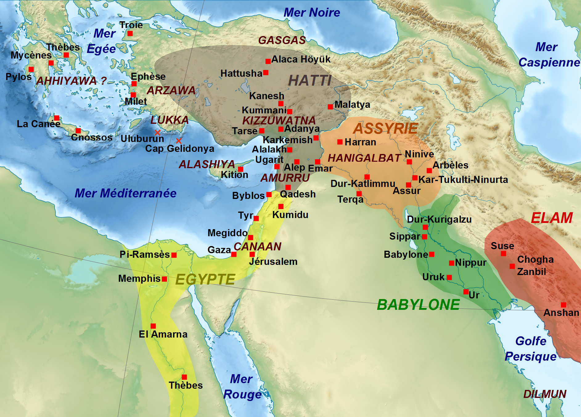
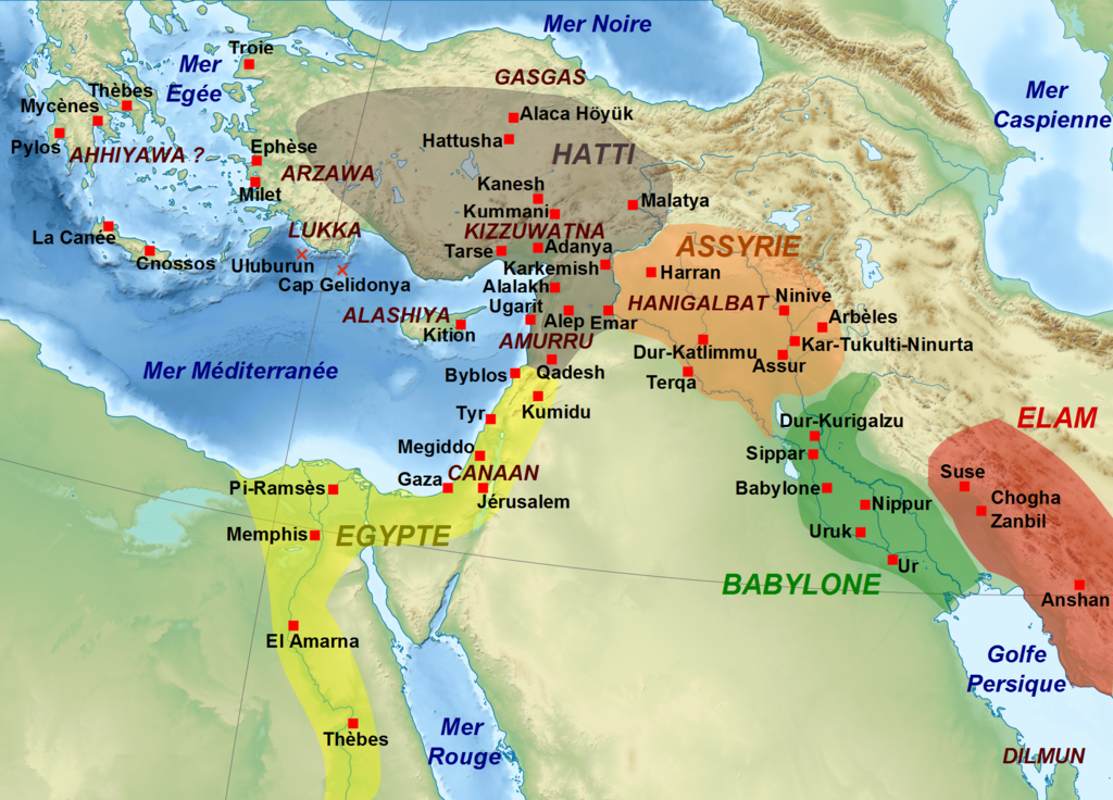
Approximate extended display map of major kingdoms in the Middle East in the 13th century BC. AD, with the location of the main cities and archaeological sites, as well as certain regions.
| Description |
English: Map showing the approximate extension of the main kingdoms of the Middle East durint the 13th century BC, with the main cities and archaeological sites, and some regions. Français : Carte montrant l'extension approximative des principaux royaumes du Moyen-Orient au XIIIe siècle av. J.-C., avec la localisation des villes et sites archéologiques principaux, ainsi que de certaines régions. |
| Date | (UTC) |
| Source | |
| Author |
|
| Other versions |
[]
|


| This is a retouched picture, which means that it has been digitally altered from its original version. Modifications: Conversion en png.. The original can be viewed here: Moyen Orient 13e siècle.svg:
|
I, the copyright holder of this work, hereby publish it under the following licenses:
This file is licensed under the Creative Commons Attribution-Share Alike 3.0 Unported, 2.5 Generic, 2.0 Generic and 1.0 Generic license.
- You are free:
- to share – to copy, distribute and transmit the work
- to remix – to adapt the work
- Under the following conditions:
- attribution – You must give appropriate credit, provide a link to the license, and indicate if changes were made. You may do so in any reasonable manner, but not in any way that suggests the licensor endorses you or your use.
- share alike – If you remix, transform, or build upon the material, you must distribute your contributions under the same or compatible license as the original.

|
Permission is granted to copy, distribute and/or modify this document under the terms of the GNU Free Documentation License, Version 1.2 or any later version published by the Free Software Foundation; with no Invariant Sections, no Front-Cover Texts, and no Back-Cover Texts. A copy of the license is included in the section entitled GNU Free Documentation License. |
You may select the license of your choice.
Original upload log
[edit]
This image is a derivative work of the following images:
- File:Moyen_Orient_13e_siècle.svg licensed with Cc-by-sa-3.0,2.5,2.0,1.0, GFDL
- 2010-11-14T11:01:14Z Zunkir 1885x1354 (4161368 Bytes) {{Information |Description={{Multilingual description |fr= Carte montrant l'extension approximative des principaux royaumes du Moyen-Orient au XIIIe siècle av. J.-C., avec la localisation des villes et sites archéologiques
Uploaded with derivativeFX
File history
Click on a date/time to view the file as it appeared at that time.
| Date/Time | Thumbnail | Dimensions | User | Comment | |
|---|---|---|---|---|---|
| current | 10:15, 14 July 2011 | | 1,885 × 1,354 (2.87 MB) | Zunkir (talk | contribs) | Ajout du pays de Lukka. |
| 11:06, 14 November 2010 |  | 1,885 × 1,354 (2.87 MB) | Zunkir (talk | contribs) | {{Information |Description={{Multilingual description |fr= Carte montrant l'extension approximative des principaux royaumes du Moyen-Orient au XIIIe siècle av. J.-C., avec la localisation des villes et sites archéologiques principaux, ainsi que de certa |
You cannot overwrite this file.
File usage on Commons
The following 6 pages use this file:
File usage on other wikis
The following other wikis use this file:
- Usage on ar.wikipedia.org
- Usage on arz.wikipedia.org
- Usage on es.wikipedia.org
- Usage on fr.wikipedia.org
- Usage on it.wikipedia.org
- Usage on pl.wikipedia.org