File:Mount Everest Climbing Routes 1924-1996 photomap-fr.svg
Jump to navigation
Jump to search

Size of this PNG preview of this SVG file: 800 × 596 pixels. Other resolutions: 320 × 238 pixels | 640 × 477 pixels | 1,024 × 763 pixels | 1,280 × 954 pixels | 2,560 × 1,907 pixels | 1,208 × 900 pixels.
Original file (SVG file, nominally 1,208 × 900 pixels, file size: 1.11 MB)
Captions
Captions
Add a one-line explanation of what this file represents
Summary
[edit]| Description |
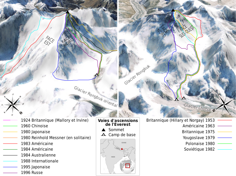
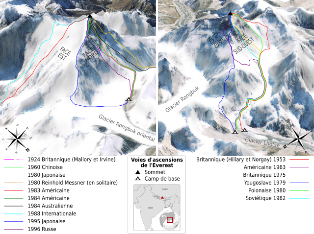
English: Map of the climbing routes opened on mount Everest by different expeditions between 1924 and 1996. Left view shows mount Everest at 215°, right view at 110°. French version. Français : Carte des voies d'ascensions ouvertes sur l'Everest par différentes expéditions entre 1924 et 1996. La vue de gauche montre l'Everest en direction du 215°, celle de droite du 110°. |
||
| Date | |||
| Source |
Own work. Sources :
|
||
| Author | Sémhur | ||
| Other versions | |||
| Attribution (required by the license) | © Sémhur / Wikimedia Commons / | ||
| SVG | W3C-validity not checked.
|
||
| Graphic Lab |

.svg)
| Object location | | View this and other nearby images on: OpenStreetMap |
|---|
Licensing
[edit]
I, the copyright holder of this work, hereby publish it under the following licenses:
| Copyleft: This work of art is free; you can redistribute it and/or modify it according to terms of the Free Art License. You will find a specimen of this license on the Copyleft Attitude site as well as on other sites. |
This file is licensed under the Creative Commons Attribution-Share Alike 4.0 International, 3.0 Unported, 2.5 Generic, 2.0 Generic and 1.0 Generic license.
- You are free:
- to share – to copy, distribute and transmit the work
- to remix – to adapt the work
- Under the following conditions:
- attribution – You must give appropriate credit, provide a link to the license, and indicate if changes were made. You may do so in any reasonable manner, but not in any way that suggests the licensor endorses you or your use.
- share alike – If you remix, transform, or build upon the material, you must distribute your contributions under the same or compatible license as the original.
You may select the license of your choice.
File history
Click on a date/time to view the file as it appeared at that time.
| Date/Time | Thumbnail | Dimensions | User | Comment | |
|---|---|---|---|---|---|
| current | 11:45, 16 June 2009 | | 1,208 × 900 (1.11 MB) | Sémhur (talk | contribs) | =={{int:summary}}== {{Information |Description= {{en|Map of the climbing routes opened on mount Everest by different expeditions between 1924 and 1996. Left view shows mount Everest at 215°, right view at 110°. French version.}} {{ |
You cannot overwrite this file.
File usage on Commons
There are no pages that use this file.
File usage on other wikis
The following other wikis use this file:
- Usage on bs.wikipedia.org
- Usage on en.wikipedia.org
- Usage on fr.wikipedia.org
- Usage on sh.wikipedia.org
- Usage on sr.wikipedia.org
- Usage on zh.wikipedia.org