File:Mount Everest - Hillary and Norgay route - map-fr.svg
Jump to navigation
Jump to search

Size of this PNG preview of this SVG file: 800 × 588 pixels. Other resolutions: 320 × 235 pixels | 640 × 470 pixels | 1,024 × 753 pixels | 1,280 × 941 pixels | 2,560 × 1,882 pixels | 1,000 × 735 pixels.
Original file (SVG file, nominally 1,000 × 735 pixels, file size: 1.03 MB)
Captions
Captions
Add a one-line explanation of what this file represents
Summary
[edit]| Description |
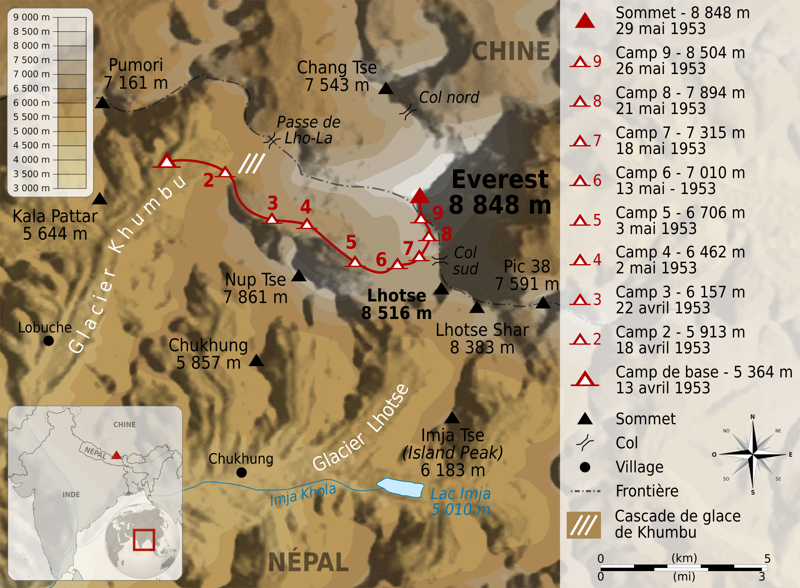
Deutsch: Karte der Route der Erstbesteigung des Mount Everest durch Edmund Hillary und Tenzing Norgay. English: Map of the route followed by Edmund Hillary and Tenzing Norgay during their climbing of Mount Everest, between 13 april 1953 and 29 may 1953. Français : Carte de l'itinéraire suivi par Edmund Hillary etTenzing Norgay lors de leur ascension de l'Everest, entre le 13 avril et le 29 mai 1953. |
||
| Date | |||
| Source |
|
||
| Author | Sémhur | ||
| Other versions | |||
| Attribution (required by the license) | © Sémhur / Wikimedia Commons / | ||
| SVG | W3C-validity not checked.
|
||
| Graphic Lab |

| Object location | | View this and other nearby images on: OpenStreetMap |
|---|
Licensing
[edit]
I, the copyright holder of this work, hereby publish it under the following licenses:
| Copyleft: This work of art is free; you can redistribute it and/or modify it according to terms of the Free Art License. You will find a specimen of this license on the Copyleft Attitude site as well as on other sites. |
This file is licensed under the Creative Commons Attribution-Share Alike 4.0 International, 3.0 Unported, 2.5 Generic, 2.0 Generic and 1.0 Generic license.
- You are free:
- to share – to copy, distribute and transmit the work
- to remix – to adapt the work
- Under the following conditions:
- attribution – You must give appropriate credit, provide a link to the license, and indicate if changes were made. You may do so in any reasonable manner, but not in any way that suggests the licensor endorses you or your use.
- share alike – If you remix, transform, or build upon the material, you must distribute your contributions under the same or compatible license as the original.
You may select the license of your choice.
File history
Click on a date/time to view the file as it appeared at that time.
| Date/Time | Thumbnail | Dimensions | User | Comment | |
|---|---|---|---|---|---|
| current | 12:03, 29 June 2009 | | 1,000 × 735 (1.03 MB) | Sémhur (talk | contribs) | {{Information |Description={{en|1=Map of the route followed by Edmund Hillary and Tenzing Norgay during their climbing of Mount Everest, between 13 april 1953 and 29 may 1953. }} {{fr|1=C |
You cannot overwrite this file.
File usage on Commons
There are no pages that use this file.
File usage on other wikis
The following other wikis use this file:
- Usage on bs.wikipedia.org
- Usage on fr.wikipedia.org
- Usage on mai.wikipedia.org
- Usage on sh.wikipedia.org