File:Morgenthau Plan map.svg
Jump to navigation
Jump to search

Size of this PNG preview of this SVG file: 671 × 442 pixels. Other resolutions: 320 × 211 pixels | 640 × 422 pixels | 1,024 × 675 pixels | 1,280 × 843 pixels | 2,560 × 1,686 pixels.
Original file (SVG file, nominally 671 × 442 pixels, file size: 132 KB)
Captions
Captions
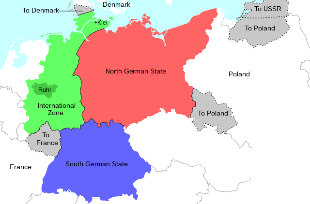
Map of the 1944 Morgenthau Plan.
Summary
[edit]
| Description |
English: Map of the 1944 Morgenthau Plan, which would have seen Germany totally demilitarised and divided into three areas: a Northern state, a Southern state, and a de-industrialised International Zone in the west, administered by "an international security organization, to be established by the United Nations". The International Zone included the Ruhr area, regarded as Germany's industrial heartland, and the important naval port of Kiel. The intention was to prevent Germany from ever again being able to develop military industry or wage war. In addition, the Saar region and surrounding area was to be ceded to France; most of Silesia and southern East Prussia to Poland; northern East Prussia to the USSR; and northern Schleswig to Denmark. |
| Date | |
| Source | Own work |
| Author | Erinthecute |
| SVG development |
Licensing
[edit]
I, the copyright holder of this work, hereby publish it under the following license:
This file is licensed under the Creative Commons Attribution-Share Alike 4.0 International license.
- You are free:
- to share – to copy, distribute and transmit the work
- to remix – to adapt the work
- Under the following conditions:
- attribution – You must give appropriate credit, provide a link to the license, and indicate if changes were made. You may do so in any reasonable manner, but not in any way that suggests the licensor endorses you or your use.
- share alike – If you remix, transform, or build upon the material, you must distribute your contributions under the same or compatible license as the original.
File history
Click on a date/time to view the file as it appeared at that time.
| Date/Time | Thumbnail | Dimensions | User | Comment | |
|---|---|---|---|---|---|
| current | 05:36, 31 July 2020 | | 671 × 442 (132 KB) | Erinthecute (talk | contribs) | Fixed background. |
| 05:32, 31 July 2020 |  | 671 × 442 (131 KB) | Erinthecute (talk | contribs) | Added highlights of the Ruhr area and Kiel, which were important elements of Moregnthau's plan for deindustrialisation and demilitarisation. | |
| 03:48, 31 July 2020 |  | 671 × 442 (128 KB) | Erinthecute (talk | contribs) | Uploaded own work with UploadWizard |
You cannot overwrite this file.
File usage on Commons
The following 2 pages use this file:
File usage on other wikis
The following other wikis use this file:
- Usage on ar.wikipedia.org
- Usage on el.wikipedia.org
- Usage on en.wikipedia.org
- Usage on he.wikipedia.org
- Usage on id.wikipedia.org
- Usage on mk.wikipedia.org
- Usage on no.wikipedia.org
- Usage on pl.wikipedia.org
- Usage on th.wikipedia.org
- Usage on tr.wikipedia.org
- Usage on vi.wikipedia.org