File:Mitchell's map of the United States - showing the principal travelling turnpike and common roads, on which are given the distances in miles from one place to another, also the courses of the (NYPL b15108647-434852).tiff

Original file (5,483 × 4,496 pixels, file size: 70.57 MB, MIME type: image/tiff)
Captions
Captions
Summary
[edit]| Description |
English: * "Entered according to Act of Congress in the year 1835 by S. Augustus Mitchell in the Clerk's Office. of the eastern district of Pennsylvania."
|
||
| Title | Mitchell's map of the United States : showing the principal travelling turnpike and common roads, on which are given the distances in miles from one place to another, also the courses of the canals & rail roads throughout the country, carefully compiled from the best authorities. | ||
| Date | |||
| Source | https://digitalcollections.nypl.org/items/510d47da-f0a5-a3d9-e040-e00a18064a99 | ||
| Author | Scan by NYPL | ||
| Permission (Reusing this file) |
|
||
| UUID | e3b9f3e0-c52a-012f-6217-3c075448cc4b | ||
| MODS | http://api.repo.nypl.org/api/v1/items/mods/510d47da-f0a5-a3d9-e040-e00a18064a99 | ||
| Origin place | Published by S. Augustus Mitchell : | ||
| Image ID | 434852 | ||
| Collection | Maps of North America | ||
| Collection UUID | 510d47da-f0a5-a3d9-e040-e00a18064a99 | ||
| NYPL catalog ID | b15108647 | ||
| NYPL Division | Lionel Pincus and Princess Firyal Map Division | ||
| Topics | Canals; Railroads; Roads |
Licensing
[edit]This image is in the public domain because it is a mere mechanical scan or photocopy of a public domain original, or – from the available evidence – is so similar to such a scan or photocopy that no copyright protection can be expected to arise. The original itself is in the public domain for the following reason:
This tag is designed for use where there may be a need to assert that any enhancements (eg brightness, contrast, colour-matching, sharpening) are in themselves insufficiently creative to generate a new copyright. It can be used where it is unknown whether any enhancements have been made, as well as when the enhancements are clear but insufficient. For known raw unenhanced scans you can use an appropriate {{PD-old}} tag instead. For usage, see Commons:When to use the PD-scan tag.  | ||||
File history
Click on a date/time to view the file as it appeared at that time.
| Date/Time | Thumbnail | Dimensions | User | Comment | |
|---|---|---|---|---|---|
| current | 18:01, 13 September 2017 |  | 5,483 × 4,496 (70.57 MB) | SteinsplitterBot (talk | contribs) | Bot: Image rotated by 90° |
| 04:11, 9 July 2016 | 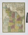 | 4,496 × 5,483 (70.54 MB) | Fæ (talk | contribs) | NYPL maps http://digitalcollections.nypl.org/items/510d47da-f0a5-a3d9-e040-e00a18064a99, part of User:Fæ/Project list/NYPL T410.1121 |
You cannot overwrite this file.
File usage on Commons
There are no pages that use this file.