File:Mexico 1821.PNG
Jump to navigation
Jump to search
Size of this preview: 659 × 599 pixels. Other resolutions: 264 × 240 pixels | 528 × 480 pixels | 844 × 768 pixels | 1,126 × 1,024 pixels | 1,669 × 1,518 pixels.
Original file (1,669 × 1,518 pixels, file size: 38 KB, MIME type: image/png)
Captions
Captions
Add a one-line explanation of what this file represents

|
File:Political divisions of Mexico 1821 (location map scheme).svg is a vector version of this file. It should be used in place of this PNG file when not inferior.
File:Mexico 1821.PNG → File:Political divisions of Mexico 1821 (location map scheme).svg
For more information, see Help:SVG. |
.svg) |
Summary
[edit]
| Description |
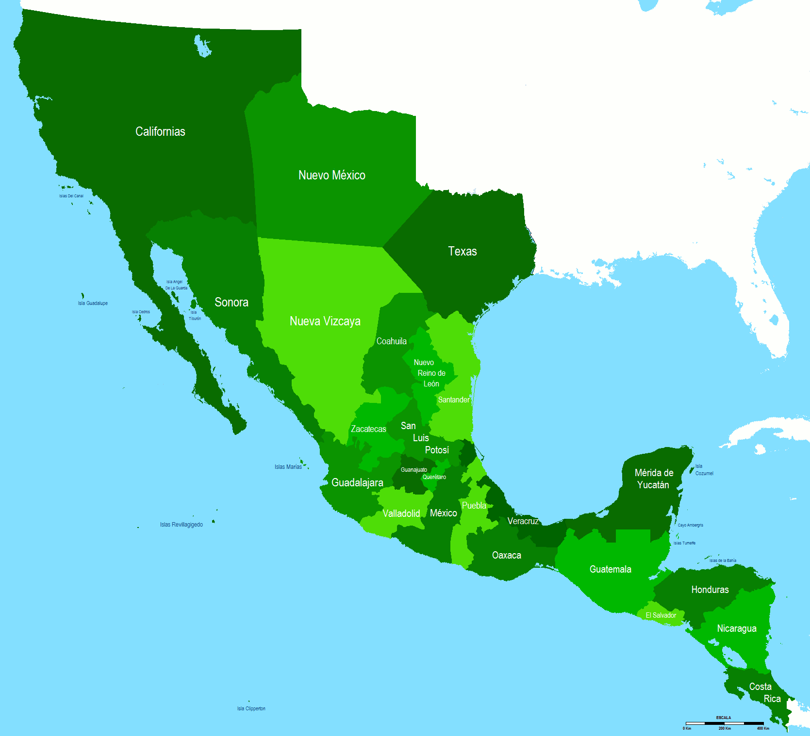
Español: Intendencias del Primer Imperio Mexicano y no español
English: Intendencies of the First Mexican Empire
Nederlands: Administratieve departementen van het eerste Mexicaanse Rijk
Italiano: I dipartimenti amministrativi del primo Impero messicano |
| Date | |
| Source | Own work |
| Author | Hpav7 |
Licensing
[edit]
| I, the copyright holder of this work, release this work into the public domain. This applies worldwide. In some countries this may not be legally possible; if so: I grant anyone the right to use this work for any purpose, without any conditions, unless such conditions are required by law. |
File history
Click on a date/time to view the file as it appeared at that time.
| Date/Time | Thumbnail | Dimensions | User | Comment | |
|---|---|---|---|---|---|
| current | 20:02, 12 July 2017 | | 1,669 × 1,518 (38 KB) | Angelgreat (talk | contribs) | Reverted to version as of 07:37, 16 February 2013 (UTC) |
| 03:10, 9 April 2017 |  | 1,669 × 1,518 (81 KB) | Hpav7 (talk | contribs) | Border lines in the north | |
| 07:37, 16 February 2013 |  | 1,669 × 1,518 (38 KB) | JohnnyMrNinja (talk | contribs) | indexed colors and increased compression, reduce size about 3x | |
| 05:57, 21 September 2011 |  | 1,669 × 1,518 (105 KB) | Hpav7 (talk | contribs) | varios ajustes | |
| 00:47, 2 March 2011 |  | 1,669 × 1,518 (105 KB) | Hpav7 (talk | contribs) | Cambios en los margenes de las Californias. | |
| 08:30, 5 January 2010 |  | 1,669 × 1,518 (105 KB) | Hpav7 (talk | contribs) | change the model of the image, colors and minor boundary adjustments. cambios en el modelo de la imagen, colores y ajustes menores de fronteras. | |
| 10:59, 4 December 2009 |  | 1,618 × 1,507 (121 KB) | Hpav7 (talk | contribs) | correction of the margins and border boundaries correccion de los margenes y limites fronterizos | |
| 17:58, 23 June 2009 |  | 1,618 × 1,507 (121 KB) | Hpav7 (talk | contribs) | {{Information |Description={{en|1=First Mexican Empire Division}} |Source=Own work by uploader |Author=Hpav7 |Date=2009-04-24 |Permission= |other_versions= }} <!--{{ImageUpload|full}}--> |
You cannot overwrite this file.
File usage on Commons
There are no pages that use this file.
File usage on other wikis
The following other wikis use this file:
- Usage on ast.wikipedia.org
- Usage on el.wikipedia.org
- Usage on en.wikipedia.org
- Usage on es.wikipedia.org
- Usage on fr.wikipedia.org
- Usage on id.wikipedia.org