File:Meghalaya COVID-19.svg
Jump to navigation
Jump to search

Size of this PNG preview of this SVG file: 800 × 430 pixels. Other resolutions: 320 × 172 pixels | 640 × 344 pixels | 1,024 × 551 pixels | 1,280 × 688 pixels | 2,560 × 1,377 pixels | 807 × 434 pixels.
Original file (SVG file, nominally 807 × 434 pixels, file size: 157 KB)
Captions
Captions
Add a one-line explanation of what this file represents
Summary
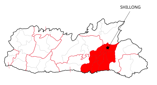
[edit]| Description | This file shows the districts of Meghalaya affected by COVID-19. |
| Date | |
| Source | Meghalaya 2012.svg |
| Author | Nilabh |
| Other versions |
[]
|


Licensing
[edit]
I, the copyright holder of this work, hereby publish it under the following licenses:
This file is licensed under the Creative Commons Attribution-Share Alike 4.0 International license.
- You are free:
- to share – to copy, distribute and transmit the work
- to remix – to adapt the work
- Under the following conditions:
- attribution – You must give appropriate credit, provide a link to the license, and indicate if changes were made. You may do so in any reasonable manner, but not in any way that suggests the licensor endorses you or your use.
- share alike – If you remix, transform, or build upon the material, you must distribute your contributions under the same or compatible license as the original.

|
Permission is granted to copy, distribute and/or modify this document under the terms of the GNU Free Documentation License, Version 1.2 or any later version published by the Free Software Foundation; with no Invariant Sections, no Front-Cover Texts, and no Back-Cover Texts. A copy of the license is included in the section entitled GNU Free Documentation License. |
You may select the license of your choice.
File history
Click on a date/time to view the file as it appeared at that time.
| Date/Time | Thumbnail | Dimensions | User | Comment | |
|---|---|---|---|---|---|
| current | 12:41, 13 May 2020 | | 807 × 434 (157 KB) | Nilabh Shivam 333 (talk | contribs) | {{Information |description={{en|1=Districts with confirmed cases in the state of meghalaya, '''as of 12 May 2020'''.}} {{legend|#FF6347|10+ confirmed cases reported}} [https://web.archive.org/web/20040606141014/www.censusindia.net/results/2001maps/assam01.html]. Note: * This map does not show the newer districts that were created after 2014. * The new districts are Chirag, Baksa, Odalguri and Kamrup Metropolitan |Source={{Derived from|Meghalaya 2012.svg|display=50}} |Date=2020-05-13 18:34 (U... |
| 18:31, 4 April 2020 |  | 631 × 530 (348 KB) | Firos ak (talk | contribs) | == {{int:filedesc}} == {{Information |Description={{en|1=This file shows the districts of en:Assam as of 2001. The map is based on a free hand trace of [https://web.archive.org/web/20040606141014/www.censusindia.net/results/2001maps/assam01.html]. Note: * This map does not show the newer districts that were created after 2001. * The new districts are Chirag, Baksa, Odalguri and Kamrup Metropolitan}} |Source={{Derived from|Assam-districts-2001.svg|display=50}} |Date=2020-04-04 18:31 (UT... | |
| 23:27, 19 August 2011 |  | 631 × 530 (211 KB) | Chaipau (talk | contribs) | Corrected the following districts: Nalbari, Barpeta, Sivasagar, Tinsukia | |
| 11:02, 5 April 2009 |  | 631 × 530 (165 KB) | Chaipau (talk | contribs) | The image is cropped to exclude empty spaces. | |
| 01:14, 5 April 2009 |  | 744 × 1,052 (165 KB) | Chaipau (talk | contribs) | {{Information |Description={{en|1=This file shows the districts of en:Assam as of 2001. The map is based on a free hand trace of [http://web.archive.org/web/20040606141014/www.censusindia.net/results/2001maps/assam01.html]. Note: * This map does not |
You cannot overwrite this file.
File usage on Commons
The following 30 pages use this file:
- অসম
- User:Magog the Ogre/Multilingual legend/2020 April 1-10
- User:Magog the Ogre/Multilingual legend/2020 May 11-20
- User talk:Timbaaa/Archives/2020/April
- File:Assam-districts-2001-bn.svg
- File:Assam-districts-2001-gu.svg
- File:Assam-districts-2001-hi.svg
- File:Assam-districts-2001-kn.svg
- File:Assam-districts-2001-mr.svg
- File:Assam-districts-2001-ne.svg
- File:Assam-districts-2001-pa.svg
- File:Assam-districts-2001-sat.svg
- File:Assam-districts-2001.svg (file redirect)
- অসম
- File:Assam-districts-2001-sat.svg
- File:Assam-districts-2001 as.svg
- Template:Other versions/File:Assam-districts-2001
- Template:Other versions/Assam-districts-2001
- File:Assam-districts-2001-gu.svg
- File:Assam-districts-2001-kn.svg
- File:Assam-districts-2001-hi.svg
- File:Assam-districts-2001-mr.svg
- File:Assam-districts-2001-bn.svg
- File:Assam-districts-2001-pa.svg
- File:Assam-districts-2001-ne.svg
- User:Magog the Ogre/Multilingual legend/2020 April 1-10
- User talk:Timbaaa/Archives/2020/April
- File:Assam-districts-2001 as.svg
- Template:Other versions/Assam-districts-2001
- Template:Other versions/File:Assam-districts-2001
File usage on other wikis
The following other wikis use this file:
- Usage on awa.wikipedia.org
- Usage on ca.wikipedia.org
- Usage on eu.wikipedia.org
- Usage on kk.wikipedia.org
- Usage on mai.wikipedia.org
- Usage on pnb.wikipedia.org
- ضلع ٹنسوکیا
- ضلع سبساگر
- ضلع ڈبروگڑھ
- ضلع دھیماجی
- ضلع جورہٹ
- ضلع لکھیمپور
- ضلع گولاگھٹ
- ضلع سونیتپور
- ضلع کربی انگلونگ
- ضلع ناگون
- ضلع ماریگون
- ضلع درنگ
- ضلع کمرپ
- ضلع نلباری
- ضلع بارپیٹا
- ضلع بونگائیگان
- ضلع گولپاڑا
- ضلع کوکراجھر
- ضلع ڈھبری
- ضلع ڈیما ہساو
- ضلع کاچڑ
- ضلع ہائیلاکنڈی
- ضلع کریم گنج
- ضلع کمرپ میٹروپولیٹن
- ضلع بکسا
- ضلع اڈلگری
- ضلع چیرنگ
- Usage on ru.wikipedia.org
View more global usage of this file.