File:Martin Groot AK Nr. 3558 Hannover, Teilansicht, Bildseite.tif
Jump to navigation
Jump to search

Size of this JPG preview of this TIF file: 800 × 577 pixels. Other resolutions: 320 × 231 pixels | 640 × 462 pixels | 1,024 × 739 pixels | 1,280 × 923 pixels | 2,560 × 1,847 pixels | 3,547 × 2,559 pixels.
Original file (3,547 × 2,559 pixels, file size: 26 MB, MIME type: image/tiff)
Captions
Captions
Add a one-line explanation of what this file represents
Summary
[edit]| Description |
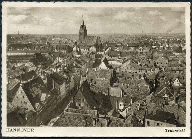
Deutsch: Ansichtskarte mit der fortlaufenden Nummer 3558 (siehe unten) aus dem Hamburger Postkarten-Großvertrieb und Verlag von Martin Groot. Der Fotograf Edmund Lill erklomm in der ersten Hälfte des 20. Jahrhunderts den noch unzerstörten Turm der Aegidienkirche in Hannover und fotografierte von dort aus in Richtung der Marktkirche von Hannover schräg über die Marktstraße und den Block aus mittelalterlichen Fachwerkhäusern an der Köbelinger Straße insbesondere im Bereich des späteren "Köbelinger Marktes". Nur wenige Zentimeter unterhalb der Straßenpflasterung warteten hier noch Anfang 2019 die ältesten Besiedlungsspuren Hannovers aus der Zeit um 150 unserer Zeitrechnung auf genauere archäologische Ausgrabungen, um die frühe Geschichte der auf der von Claudius Ptolemäus gezeichneten Karte von Germania Magna eingezeichneten Siedlung Tulifurdum zu ergründen. Diese ältesten Besiedlungsspuren im Bereich des heutigen Köbelinger Marktes hatte auch schon der Museumsdirektor Helmut Plath nach stichprobenartigen Grabungen unmittelbar nach dem Zweiten Weltkrieg nachgewiesen.
|
| Date | circa 1930 |
| Source | Scan vom Original: Bernd Schwabe im Wikipedia-Büro Hannover |
| Author | Foto: Edmund Lill |
| Other versions |
|
| Camera location | | View this and other nearby images on: OpenStreetMap |
|---|
Licensing
[edit]This file is licensed under the Creative Commons Attribution-Share Alike 4.0 International license.
- You are free:
- to share – to copy, distribute and transmit the work
- to remix – to adapt the work
- Under the following conditions:
- attribution – You must give appropriate credit, provide a link to the license, and indicate if changes were made. You may do so in any reasonable manner, but not in any way that suggests the licensor endorses you or your use.
- share alike – If you remix, transform, or build upon the material, you must distribute your contributions under the same or compatible license as the original.
File history
Click on a date/time to view the file as it appeared at that time.
| Date/Time | Thumbnail | Dimensions | User | Comment | |
|---|---|---|---|---|---|
| current | 15:07, 18 February 2019 |  | 3,547 × 2,559 (26 MB) | Bernd Schwabe in Hannover (talk | contribs) | User created page with UploadWizard |
You cannot overwrite this file.
File usage on Commons
The following 2 pages use this file:
File usage on other wikis
The following other wikis use this file:
- Usage on de.wikipedia.org
Metadata
Categories:
- Edmund Lill
- Martin Groot
- Aegidienkirche (Hannover)
- Marktstraße (Hannover)
- Historical images of Marktkirche (Hannover)
- Markthalle Hannover
- Karmarschstraße (Hannover)
- Köbelinger Markt (Hannover)
- Köbelingerstraße (Hannover)
- Senior-Blumenberg-Gang (Hannover)
- Röselerstraße (Hannover)
- Schulstraße (Hannover)
- 1939 in Hannover
- Postcards of Hannover