File:Mapofkhorasan1775.png
Jump to navigation
Jump to search

Size of this preview: 546 × 600 pixels. Other resolutions: 218 × 240 pixels | 437 × 480 pixels | 699 × 768 pixels | 932 × 1,024 pixels | 1,952 × 2,144 pixels.
Original file (1,952 × 2,144 pixels, file size: 258 KB, MIME type: image/png)
Captions
Captions
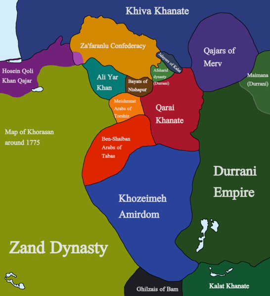
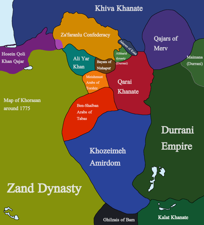
A map of Khorasan in 1775
Summary
[edit]
| Description |
English: A map of Khorasan in 1775, showing the various factions that emerged in Khorasan after the death of Nader Shah and subsequent battles between Nader Mirza Afshar and Nasrullah Mirza Afshar. Sources used for the Creation of this map are as follows:
The History of Persia, From the Most Early Period to the Present Time by Sir John Malcolm, various Encyclopedia Iranica articles, A Historical Atlas of Central Asia by Yuri Bregel, The gulf2000 project, THE REVOLT OF HOSEIN QOLI KHAN QAJAR, 1769-1777 by Shohei Komaki, Russian Wikipedia, and Evolution of Eastern Iranian Boundaries: Role of the Khozeimeh Amirdom of Qaenat and Sistan by Pirouz Mojtahed-Zadeh. |
| Date | |
| Source | Own work |
| Author | Kailanmapper |
Licensing
[edit]
I, the copyright holder of this work, hereby publish it under the following license:
This file is licensed under the Creative Commons Attribution-Share Alike 4.0 International license.
- You are free:
- to share – to copy, distribute and transmit the work
- to remix – to adapt the work
- Under the following conditions:
- attribution – You must give appropriate credit, provide a link to the license, and indicate if changes were made. You may do so in any reasonable manner, but not in any way that suggests the licensor endorses you or your use.
- share alike – If you remix, transform, or build upon the material, you must distribute your contributions under the same or compatible license as the original.
File history
Click on a date/time to view the file as it appeared at that time.
| Date/Time | Thumbnail | Dimensions | User | Comment | |
|---|---|---|---|---|---|
| current | 14:33, 18 May 2021 | | 1,952 × 2,144 (258 KB) | Kailanmapper (talk | contribs) | Uploaded own work with UploadWizard |
You cannot overwrite this file.
File usage on Commons
There are no pages that use this file.
File usage on other wikis
The following other wikis use this file:
- Usage on ar.wikipedia.org
- Usage on az.wikipedia.org
- Usage on en.wikipedia.org
- Usage on fa.wikipedia.org
- Usage on pnb.wikipedia.org
- Usage on ru.wikipedia.org
- Usage on ur.wikipedia.org
Metadata
Categories:
- Iran in the 1770s
- Afsharid dynasty
- Zand dynasty
- Qajar dynasty
- Khorasan Turks
- Khorasan (historical region)
- Maps of the history of Iran
- Maps of the Durrani Empire
- Maps of Razavi Khorasan Province
- Maps of South Khorasan Province
- Maps of North Khorasan Province
- History of Razavi Khorasan Province
- History of South Khorasan Province
- History of North Khorasan Province
- Torshiz