File:Map showing NWFP and FATA.png
Jump to navigation
Jump to search

Size of this preview: 535 × 599 pixels. Other resolutions: 214 × 240 pixels | 429 × 480 pixels.
Original file (800 × 896 pixels, file size: 218 KB, MIME type: image/png)
Captions
Captions
Add a one-line explanation of what this file represents

|
This locator map image could be re-created using vector graphics as an SVG file. This has several advantages; see Commons:Media for cleanup for more information. If an SVG form of this image is available, please upload it and afterwards replace this template with
{{vector version available|new image name}}.
It is recommended to name the SVG file “Map showing NWFP and FATA.svg”—then the template Vector version available (or Vva) does not need the new image name parameter. |
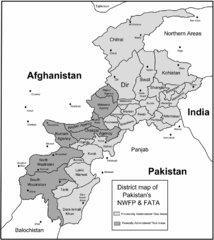
| Description | Map of Pakistan's North-West Frontier Province and Federally Administered Tribal Areas. |
| Date | |
| Source | self-made using map provided here at en.wikinews.org with permission for derivative work by Riaz Hakeem as RHakeem. |
| Author | Ed Brown as Edbrown05 |
| Permission (Reusing this file) |
PD |
| Other versions | Image:NWFP and FATA.jpg n:image:Nwfpmap.png |
Bawolff 23:28, 3 May 2007 (UTC)
This file is licensed under the Creative Commons Attribution 2.5 Generic license.
- You are free:
- to share – to copy, distribute and transmit the work
- to remix – to adapt the work
- Under the following conditions:
- attribution – You must give appropriate credit, provide a link to the license, and indicate if changes were made. You may do so in any reasonable manner, but not in any way that suggests the licensor endorses you or your use.
File history
Click on a date/time to view the file as it appeared at that time.
| Date/Time | Thumbnail | Dimensions | User | Comment | |
|---|---|---|---|---|---|
| current | 08:55, 7 May 2007 | | 800 × 896 (218 KB) | Bawolff (talk | contribs) | Reverted to earlier revision |
| 08:55, 7 May 2007 |  | 6,325 × 7,085 (5.06 MB) | Bawolff (talk | contribs) | Reverted to earlier revision | |
| 08:55, 7 May 2007 |  | 6,325 × 7,085 (5.06 MB) | Bawolff (talk | contribs) | Reverted to earlier revision | |
| 08:55, 7 May 2007 |  | 800 × 896 (218 KB) | Bawolff (talk | contribs) | Reverted to earlier revision | |
| 08:54, 7 May 2007 |  | 6,325 × 7,085 (5.06 MB) | Bawolff (talk | contribs) | Reverted to earlier revision | |
| 05:47, 7 May 2007 |  | 800 × 896 (218 KB) | Edbrown05~commonswiki (talk | contribs) | {{Information |Description= |Source= |Date= |Author= }} | |
| 05:39, 7 May 2007 |  | 6,325 × 7,085 (5.06 MB) | Edbrown05~commonswiki (talk | contribs) | {{Information |Description= |Source= |Date= |Author= }} | |
| 23:28, 3 May 2007 |  | 6,325 × 7,085 (833 KB) | Bawolff (talk | contribs) | {{Information |Description=Map of Pakistan's North-West Frontier Province and Federally Administered Tribal Areas. |Source=self-made using map provided [http://en.wikinews |
You cannot overwrite this file.
File usage on Commons
The following page uses this file:
File usage on other wikis
The following other wikis use this file:
- Usage on en.wikinews.org
- Usage on fr.wikinews.org