Category:Maps of Khyber Pakhtunkhwa
Jump to navigation
Jump to search
Provinces of Pakistan: Balochistan · Khyber Pakhtunkhwa · Punjab · Sindh ·
Territories: Azad Kashmir · Gilgit-Baltistan · Islamabad Capital Territory ·
Territories: Azad Kashmir · Gilgit-Baltistan · Islamabad Capital Territory ·
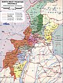
English: Maps of the of Khyber Pakhtunkhwa Province, formerly named North-West Frontier Province, in northern Pakistan.
Subcategories
This category has the following 6 subcategories, out of 6 total.
E
L
M
O
Pages in category "Maps of Khyber Pakhtunkhwa"
This category contains only the following page.
Media in category "Maps of Khyber Pakhtunkhwa"
The following 32 files are in this category, out of 32 total.
-
 Administrative Divisions of NWFP.jpg 833 × 1,103; 295 KB
-
 BHANDA.png 419 × 599; 337 KB
-
 BlankMap-NWFP(Pak)2.92.png 610 × 1,042; 33 KB
-
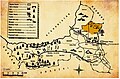
 D.I.khan map.jpg 1,422 × 1,975; 466 KB
-
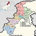 Districts of Khyber Pakhtunkhwa, Pakistan with district names- in 2022 by Vijay Kumar.jpg 19,200 × 19,200; 13.11 MB
-
 Kanshian in Mansehra-01.jpg 937 × 677; 100 KB
-
 Kanshian.jpg 3,508 × 2,480; 637 KB
-
 Khyber Agency Map, indicating Tehsil Mullagori.jpg 700 × 495; 68 KB
-
 Khyber Pakhtunkhwa map.png 68 × 84; 5 KB
-
 Khyber Pakhtunkhwa, KPK, Map.png 558 × 600; 80 KB
-
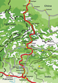
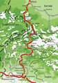 KKH (uk).png 595 × 851; 1.49 MB
-
 KKH.png 595 × 851; 1.46 MB
-
 KPK Districts Political Locator.png 1,323 × 1,554; 912 KB
-
 Kurram.png 731 × 548; 519 KB
-
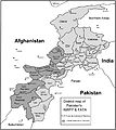
 Map showing NWFP and FATA.png 800 × 896; 218 KB
-
 Mulla Gori Tehsil Map.jpg 820 × 541; 164 KB
-
 Nathia Gali Sub Div.svg 1,027 × 658; 14 KB
-
 NWFP and FATA.jpg 6,325 × 7,085; 1.96 MB
-
 NWFP and FATA.png 425 × 500; 467 KB
-
 NWFP FATA.svg 1,000 × 1,075; 171 KB
-
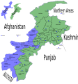
 Pakistan KPK FATA areas with localisation map.svg 1,000 × 1,075; 243 KB
-
 Pakistan NWFP FATA areas with localisation map de.svg 1,015 × 1,123; 141 KB
-
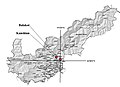
 Physical Map of NWFP.jpg 833 × 1,109; 245 KB
-
 Sarhad Province.svg 1,000 × 1,075; 2.54 MB
-
 Sarhad Province2.PNG 558 × 600; 47 KB
-
 Sheikh badin Map.jpg 1,006 × 1,280; 332 KB
-
 Sheikh badin Maps.jpg 1,177 × 815; 269 KB
-
 NWPF-Pakistan.png 1,035 × 1,065; 232 KB
-
 Tehsil Mullagori Location Khyber Agency Map.jpg 1,689 × 1,246; 219 KB
-
 Tehsil Mullagori Map.jpg 2,692 × 1,760; 627 KB
-
 The most populous cities of Khyber Pakhtunkhwa, Pakistan.png 5,340 × 3,840; 2.45 MB
-
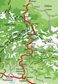
 काराकोरम राजमार्ग.png 595 × 851; 450 KB


.png)


2.92.png)