File:Map showing Camarones Bay and adjoining capes, Argentina. LOC 89696435.tif
Jump to navigation
Jump to search

Size of this JPG preview of this TIF file: 800 × 518 pixels. Other resolutions: 320 × 207 pixels | 640 × 414 pixels | 1,024 × 663 pixels | 1,280 × 828 pixels | 2,560 × 1,657 pixels | 4,603 × 2,979 pixels.
Original file (4,603 × 2,979 pixels, file size: 39.23 MB, MIME type: image/tiff)
Captions
Captions
Add a one-line explanation of what this file represents
Summary
[edit]| Description |
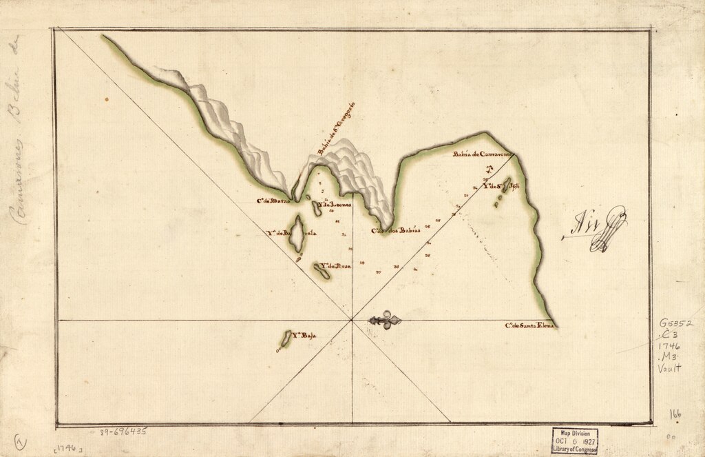
English: Dated by comparison with similar map attributed to Francisco Gómez. Relief shown by shading. Depths shown by soundings. Oriented with north to the right. Watermark: IV. Black and brown inks and watercolor. Mounted on cloth backing. LC Luso-Hispanic World, 137 Available also through the Library of Congress Web site as a raster image. Annotated in black ink: N 11 [indecipherable]. Maggs number annotated in pencil in lower right margin: 166. Annotated in brown ink on verso: Este plano es copia del qe. [indecipherable] Dn. Manuel Ioaquin de Saptola Alferes de fragta. graduado de la Rl. Armada y Piloto primero particular; neserita de comprobación. Vault |
||
| Title | [Map showing Camarones Bay and adjoining capes, Argentina]. | ||
| Shelf ID | G5352.C3 1746 .M3 | ||
| Date | |||
| Source | https://www.loc.gov/item/89696435/ | ||
| Author | Unknown author | ||
| Permission (Reusing this file) |
|
||
| Other versions |
|
||
| Location | Argentina · Camarones Bay | ||
| Part of | American Memory · Catalog · Geography And Map Division · Cultural Landscapes | ||
| Subject | Maps, Manuscript · Camarones Bay (Argentina) · Argentina · Early Works To 1800 · Camarones Bay |


Licensing
[edit]|
This is a faithful photographic reproduction of a two-dimensional, public domain work of art. The work of art itself is in the public domain for the following reason:
The official position taken by the Wikimedia Foundation is that "faithful reproductions of two-dimensional public domain works of art are public domain".
This photographic reproduction is therefore also considered to be in the public domain in the United States. In other jurisdictions, re-use of this content may be restricted; see Reuse of PD-Art photographs for details. | ||||
File history
Click on a date/time to view the file as it appeared at that time.
| Date/Time | Thumbnail | Dimensions | User | Comment | |
|---|---|---|---|---|---|
| current | 04:32, 22 May 2018 |  | 4,603 × 2,979 (39.23 MB) | Fæ (talk | contribs) | LOC Maps https://www.loc.gov/item/89696435/ #13141 |
You cannot overwrite this file.
File usage on Commons
The following 3 pages use this file: