File:Map of the town of Concord, Middlesex County Mass. LOC 2012593522.jpg
Jump to navigation
Jump to search

Size of this preview: 757 × 599 pixels. Other resolutions: 303 × 240 pixels | 607 × 480 pixels | 970 × 768 pixels | 1,280 × 1,013 pixels | 2,560 × 2,026 pixels | 9,414 × 7,452 pixels.
Original file (9,414 × 7,452 pixels, file size: 9.21 MB, MIME type: image/jpeg)
Captions
Captions
Add a one-line explanation of what this file represents
Summary
[edit]| Description |
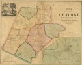
English: Relief shown by hachures. Available also through the Library of Congress Web site as a raster image. "White Pond & Walden Pond from surveys by H.D. Thoreau, Civ. Engr." Includes notes, ancillary map of Concord village, and illustration. LC copy shellacked and mounted on cloth. |
||
| Title | Map of the town of Concord, Middlesex County Mass. | ||
| Shelf ID | G3764.C72 1852 .W3 | ||
| Date | |||
| Source | https://www.loc.gov/item/2012593522/ | ||
| Author | Walling, Henry Francis | ||
| Permission (Reusing this file) |
|
||
| Other versions |
|
||
| Location | United States · Town · Massachusetts · Concord | ||
| Part of | American Memory · Cities And Towns · Catalog · Geography And Map Division | ||
| Subject | United States · Maps · Concord · Massachusetts · Concord (Mass. : Town) |

Licensing
[edit]
|
This is a faithful photographic reproduction of a two-dimensional, public domain work of art. The work of art itself is in the public domain for the following reason:
The official position taken by the Wikimedia Foundation is that "faithful reproductions of two-dimensional public domain works of art are public domain".
This photographic reproduction is therefore also considered to be in the public domain in the United States. In other jurisdictions, re-use of this content may be restricted; see Reuse of PD-Art photographs for details. | ||||
File history
Click on a date/time to view the file as it appeared at that time.
| Date/Time | Thumbnail | Dimensions | User | Comment | |
|---|---|---|---|---|---|
| current | 06:19, 5 June 2018 | | 9,414 × 7,452 (9.21 MB) | Fæ (talk | contribs) | LOC Maps https://www.loc.gov/item/2012593522/ #5363 |
You cannot overwrite this file.
File usage on Commons
The following page uses this file: