File:Map of the fortifications of Columbus, Ky. LOC 2008627288.tif
Jump to navigation
Jump to search

Size of this JPG preview of this TIF file: 594 × 600 pixels. Other resolutions: 238 × 240 pixels | 475 × 480 pixels | 761 × 768 pixels | 1,014 × 1,024 pixels | 2,028 × 2,048 pixels | 11,391 × 11,501 pixels.
Original file (11,391 × 11,501 pixels, file size: 374.82 MB, MIME type: image/tiff)
Captions
Captions
Add a one-line explanation of what this file represents
Summary
[edit]| Warning | The original file is very high-resolution. It might not load properly or could cause your browser to freeze when opened at full size. |
|---|
| Description |
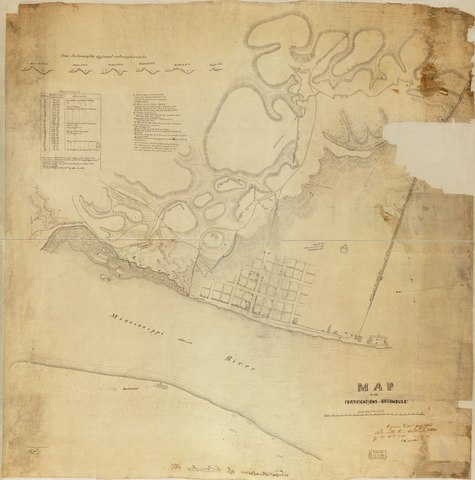
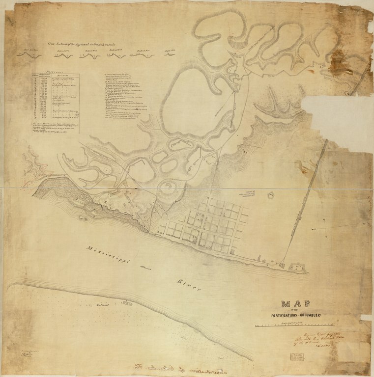
English: Relief shown by hachures. Detailed map of Columbus and environs, showing Confederate fortifications, rifle pits and gun emplacements, roads, railroad, and drainage. In the lower right corner: Engineer Dept., July 18/64. Recd. with Gen. Cullum's letter of the 16th inst. (C.5621). Imperfect: Missing small sections along sheet edges. Mounted on cloth backing in 2 parts. Available also through the Library of Congress Web site as a raster image. Includes "Cross sections of the different intrenchments" and a list of "References." LC Civil War Maps (2nd ed.), 218 |
||
| Title | Map of the fortifications of Columbus, Ky. | ||
| Shelf ID | G3954.C515S5 1862 .M8 | ||
| Date | |||
| Source | https://www.loc.gov/item/2008627288/ | ||
| Author | Muller, John; Clough, J. | ||
| Permission (Reusing this file) |
|
||
| Other versions |
|
||
| Location | United States · Columbus Region · Kentucky | ||
| Part of | Military Battles And Campaigns · American Memory · Civil War Maps · Catalog · Geography And Map Division | ||
| Subject | Maps, Manuscript · Fortification · Columbus Region · Kentucky · United States · Maps · Civil War · Columbus Region (Ky.) · History |


Licensing
[edit]|
This is a faithful photographic reproduction of a two-dimensional, public domain work of art. The work of art itself is in the public domain for the following reason:
The official position taken by the Wikimedia Foundation is that "faithful reproductions of two-dimensional public domain works of art are public domain".
This photographic reproduction is therefore also considered to be in the public domain in the United States. In other jurisdictions, re-use of this content may be restricted; see Reuse of PD-Art photographs for details. | ||||
File history
Click on a date/time to view the file as it appeared at that time.
| Date/Time | Thumbnail | Dimensions | User | Comment | |
|---|---|---|---|---|---|
| current | 06:43, 11 June 2018 |  | 11,391 × 11,501 (374.82 MB) | Fæ (talk | contribs) | LOC Maps https://www.loc.gov/item/2008627288/ #11548 |
You cannot overwrite this file.
File usage on Commons
The following page uses this file: