File:Map of the Samanid amirate at the death of Nasr II, 943.svg

Original file (SVG file, nominally 1,603 × 1,127 pixels, file size: 6.95 MB)
Captions
Captions
Summary
[edit]
| Description |
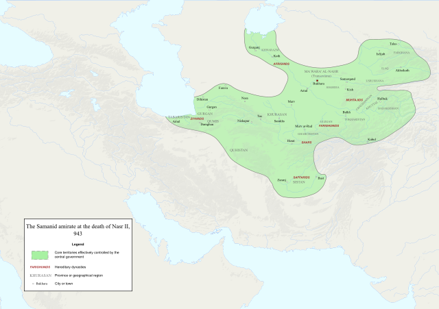
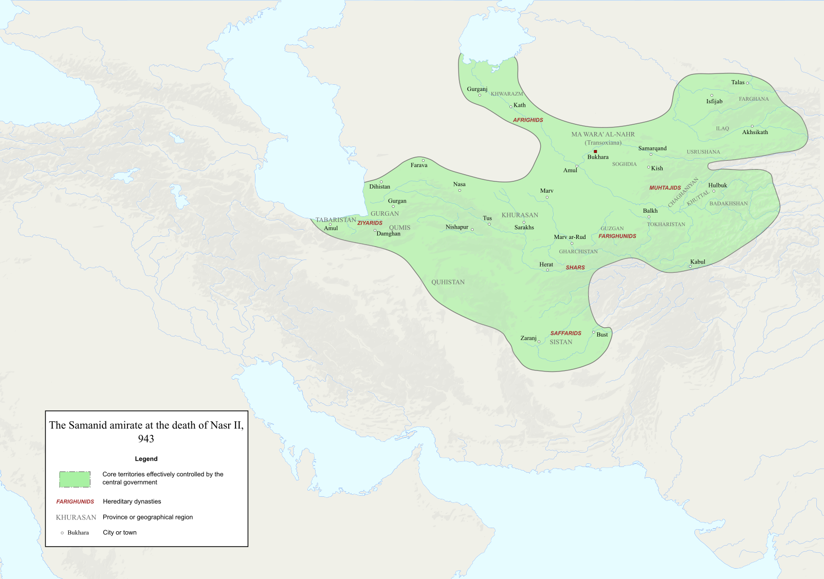
English: Map of the Samanid amirate at the death of Nasr II. |
| Source |
Map is mainly based on two maps of mid 10th-century Central Asia under the Samanids in the pages 23 and 25 of An Historical Atlas of Central Asia, written by Yuri Bregel and published by Brill, supplied by NAṢR (I) B. AḤMAD (I) B. ESMĀʿIL [1] and Frye, R. N. (1975). "The Sāmānids". In Frye, Richard N. (ed.). The Cambridge History of Iran, Volume 4: From the Arab Invasion to the Saljuqs. Cambridge: Cambridge University Press. pp. 136–161. Since the maps in the source "only" showed Central Asia, I was missing very few parts of the southern border of the Samanids, which I used the following sources to construct;
|
| Author | Original file by Ro4444, edited by me |
| Permission (Reusing this file) |
File:Abbasid_Caliphate_891-892.png |
Licensing
[edit]

|
Permission is granted to copy, distribute and/or modify this document under the terms of the GNU Free Documentation License, Version 1.2 or any later version published by the Free Software Foundation; with no Invariant Sections, no Front-Cover Texts, and no Back-Cover Texts. A copy of the license is included in the section entitled GNU Free Documentation License. |
- You are free:
- to share – to copy, distribute and transmit the work
- to remix – to adapt the work
- Under the following conditions:
- attribution – You must give appropriate credit, provide a link to the license, and indicate if changes were made. You may do so in any reasonable manner, but not in any way that suggests the licensor endorses you or your use.
- share alike – If you remix, transform, or build upon the material, you must distribute your contributions under the same or compatible license as the original.
File history
Click on a date/time to view the file as it appeared at that time.
| Date/Time | Thumbnail | Dimensions | User | Comment | |
|---|---|---|---|---|---|
| current | 14:06, 3 December 2022 | | 1,603 × 1,127 (6.95 MB) | HistoryofIran (talk | contribs) | ditto |
| 14:02, 3 December 2022 |  | 1,603 × 1,127 (6.95 MB) | HistoryofIran (talk | contribs) | several adjustments | |
| 02:22, 3 October 2020 |  | 1,603 × 1,127 (6.91 MB) | HistoryofIran (talk | contribs) | removed banijurids, didnt rule back then | |
| 02:19, 3 October 2020 |  | 1,603 × 1,127 (6.92 MB) | HistoryofIran (talk | contribs) | banijurids | |
| 16:32, 2 October 2020 |  | 1,603 × 1,127 (6.92 MB) | HistoryofIran (talk | contribs) | moved Soghdia a bit more west | |
| 16:28, 2 October 2020 |  | 1,603 × 1,127 (6.92 MB) | HistoryofIran (talk | contribs) | Ghur | |
| 16:22, 2 October 2020 |  | 1,603 × 1,127 (6.92 MB) | HistoryofIran (talk | contribs) | small fix | |
| 15:02, 2 October 2020 |  | 1,603 × 1,127 (6.94 MB) | HistoryofIran (talk | contribs) | under Nasr II | |
| 13:16, 2 October 2020 |  | 1,603 × 1,127 (6.93 MB) | HistoryofIran (talk | contribs) | added capital dot, fixed border in tabaristan | |
| 04:23, 2 October 2020 |  | 1,603 × 1,127 (6.92 MB) | HistoryofIran (talk | contribs) | {{subst:Upload marker added by en.wp UW}} {{Information |Description = {{en|Map of the traditional domain of the Samanids.}} |Source = Cambridge History of Iran vol 4, Iranica, etc. Might add a more detailed list in the future. |Author = Original file by Ro4444, edited by me |Permission = File:Abbasid_Caliphate_891-892.png }} |
You cannot overwrite this file.
File usage on Commons
The following page uses this file:
- File:Map of the traditional domain of the Samanids.svg (file redirect)
File usage on other wikis
The following other wikis use this file:
- Usage on az.wikipedia.org
- Usage on en.wikipedia.org
- Usage on id.wikipedia.org
- Usage on it.wikipedia.org
- Usage on ky.wikipedia.org
- Usage on lt.wikipedia.org
- Usage on mg.wikipedia.org
- Usage on pl.wikipedia.org
- Usage on ps.wikipedia.org
- Usage on ru.wikipedia.org
- Usage on sk.wikipedia.org
- Usage on ta.wikipedia.org
- Usage on tr.wikipedia.org
- Usage on uz.wikipedia.org
- Usage on zh.wikipedia.org