File:Map of the Philadelphia & Baltimore Rail Road as located by W. Strickland & B. H. Latrobe, Esqrs., civ. engineers. Showing also the present route by steamboat & the N. Castle R. Road, & that proposed LOC 74692596.tif
Jump to navigation
Jump to search

Size of this JPG preview of this TIF file: 800 × 244 pixels. Other resolutions: 320 × 98 pixels | 640 × 195 pixels | 1,024 × 312 pixels | 1,280 × 390 pixels | 2,560 × 780 pixels | 8,138 × 2,480 pixels.
Original file (8,138 × 2,480 pixels, file size: 57.74 MB, MIME type: image/tiff)
Captions
Captions
Add a one-line explanation of what this file represents
Summary
[edit]| Description |
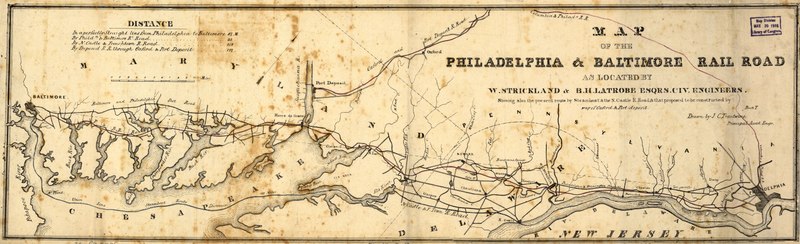
English: Map of an area between Philadelphia and Baltimore showing drainage, cities and towns, post roads, and boundaries. Chartered in Maryland in May, 1852. [From published bibliography]. |
||
| Title | Map of the Philadelphia & Baltimore Rail Road as located by W. Strickland & B. H. Latrobe, Esqrs., civ. engineers. Showing also the present route by steamboat & the N. Castle R. Road, & that proposed to be constructed by way of Oxford & Port-Deposit. | ||
| Shelf ID | G3791.P3 1853 .T7 | ||
| Date | |||
| Source | https://www.loc.gov/item/74692596/ | ||
| Author | Trautwine, John C. (John Cresson); Strickland, William; Latrobe, Benj. H. (Benjamin Henry); Trautwine, John C. | ||
| Permission (Reusing this file) |
|
||
| Other versions |
|
||
| Location | United States · Middle Atlantic States | ||
| Part of | American Memory · Catalog · Railroad Maps, 1828-1900 · Geography And Map Division · Transportation And Communication | ||
| Subject | United States · Maps · Philadelphia And Baltimore Railroad · Middle Atlantic States · Railroads |

Licensing
[edit]|
This is a faithful photographic reproduction of a two-dimensional, public domain work of art. The work of art itself is in the public domain for the following reason:
The official position taken by the Wikimedia Foundation is that "faithful reproductions of two-dimensional public domain works of art are public domain".
This photographic reproduction is therefore also considered to be in the public domain in the United States. In other jurisdictions, re-use of this content may be restricted; see Reuse of PD-Art photographs for details. | ||||
File history
Click on a date/time to view the file as it appeared at that time.
| Date/Time | Thumbnail | Dimensions | User | Comment | |
|---|---|---|---|---|---|
| current | 15:52, 18 May 2018 | 8,138 × 2,480 (57.74 MB) | Fæ (talk | contribs) | LOC Maps https://www.loc.gov/item/74692596/ #10838 |
You cannot overwrite this file.
File usage on Commons
The following page uses this file: