File:Map of the Crown Prince Islands, Disco (sic) Bay, Greenland LOC 2009584739.tif
Jump to navigation
Jump to search

Size of this JPG preview of this TIF file: 800 × 592 pixels. Other resolutions: 320 × 237 pixels | 640 × 473 pixels | 1,024 × 758 pixels | 1,280 × 947 pixels | 2,560 × 1,894 pixels | 10,077 × 7,455 pixels.
Original file (10,077 × 7,455 pixels, file size: 214.93 MB, MIME type: image/tiff)
Captions
Captions
Add a one-line explanation of what this file represents
Summary
[edit]| Description |
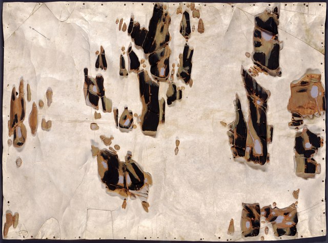
English: The present model was made by Mr. Sandgreen to represent the kinds of models made in the past by Eskimo ancestors. The wooden pieces were carved to represent the actual landform of the islands and the carvings were attached to the sealskin base within pencil location outlines. Title and other bibliographic information were taken from a typewritten data sheet (3 x 5 in.) affixed to the bottom of the plywood baseboard. Oriented with north toward the upper right (appxrox. 40° west of north). Manuscript: The islands are painted in black, brown, and light blue to represent their actual colors. One of the carved wooden islands is missing adjacent to the left sheet edge near the N.W. corner. Includes north-south direction arrow drawn in lead-pencil at upper right and pencilled no. at sheet edge near the direction arrow. Available also through the Library of Congress Web site as a raster image. Vault |
||
| Title | Map of the Crown Prince Islands, Disco [sic] Bay, Greenland | ||
| Shelf ID | G3382.C5C18 1926 .S3 | ||
| Date | |||
| Source | https://www.loc.gov/item/2009584739/ | ||
| Author | Sandgreen, Silas | ||
| Permission (Reusing this file) |
|
||
| Other versions |
|
||
| Location | Greenland · Disko Bay. · Disko Bay · Greenland · Crown Prince Islands · Crown Prince Islands. | ||
| Part of | American Memory · General Maps · Catalog · Geography And Map Division | ||
| Subject | Crown Prince Islands (Greenland) · Greenland · Relief Models · Maps, Manuscript · Disko Bay · Crown Prince Islands · Disko Bay (Greenland) |

_Bay,_Greenland_LOC_2009584739.jpg)
Licensing
[edit]|
This is a faithful photographic reproduction of a two-dimensional, public domain work of art. The work of art itself is in the public domain for the following reason:
The official position taken by the Wikimedia Foundation is that "faithful reproductions of two-dimensional public domain works of art are public domain".
This photographic reproduction is therefore also considered to be in the public domain in the United States. In other jurisdictions, re-use of this content may be restricted; see Reuse of PD-Art photographs for details. | ||||
File history
Click on a date/time to view the file as it appeared at that time.
| Date/Time | Thumbnail | Dimensions | User | Comment | |
|---|---|---|---|---|---|
| current | 15:07, 4 June 2018 |  | 10,077 × 7,455 (214.93 MB) | Fæ (talk | contribs) | LOC Maps https://www.loc.gov/item/2009584739/ #19845 |
You cannot overwrite this file.
File usage on Commons
The following page uses this file: