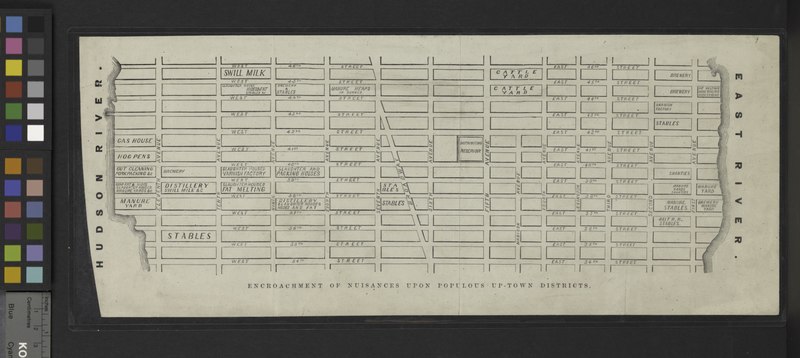
File:Map of that part of New York City between 34th St. and 46th St., and the East and Hudson Rivers, showing) encroachment of nuisances upon populous up-town districts. NYPL1802051.tiff
Jump to navigation
Jump to search

Size of this JPG preview of this TIF file: 800 × 358 pixels. Other resolutions: 320 × 143 pixels | 640 × 286 pixels | 1,024 × 458 pixels | 1,280 × 573 pixels | 2,560 × 1,145 pixels | 6,452 × 2,886 pixels.
Original file (6,452 × 2,886 pixels, file size: 53.28 MB, MIME type: image/tiff)
Captions
Captions
Add a one-line explanation of what this file represents
Summary
[edit]| Description | Maps of New York City and State / New York City / Manhattan; [Map of that part of New York City between 34th St. and 46th St., and the East and Hudson Rivers, showing] encroachment of nuisances upon populous up-town districts. | |||||||||||||||||||||||
| Item physical description | 1 sheet, mounted on muslin; 18 x 42 cm. | |||||||||||||||||||||||
| Date | ||||||||||||||||||||||||
| Source |
http://digitalgallery.nypl.org/nypldigital/dgkeysearchdetail.cfm?imageID=1802051
|
|||||||||||||||||||||||
| Author | ||||||||||||||||||||||||
| Permission (Reusing this file) |
From The Lionel Pincus and Princess Firyal Map Division. http://maps.nypl.org
|
|||||||||||||||||||||||
| Location | Stephen A. Schwarzman Building / The Lionel Pincus and Princess Firyal Map Division | |||||||||||||||||||||||
| Digital item published | 7-23-2010; updated 5-16-2012 | |||||||||||||||||||||||
| Digital ID | 1802051 | |||||||||||||||||||||||

The making of this file was supported by Wikimedia UK.
To see other files made with the support of Wikimedia UK, please see the category Supported by Wikimedia UK.
|
File history
Click on a date/time to view the file as it appeared at that time.
| Date/Time | Thumbnail | Dimensions | User | Comment | |
|---|---|---|---|---|---|
| current | 23:21, 9 May 2014 |  | 6,452 × 2,886 (53.28 MB) | Fæ (talk | contribs) | GWToolset: Creating mediafile for Fæ. Tranche 4 -12906 @11:45 BST, 9 May 2014 |
You cannot overwrite this file.
File usage on Commons
There are no pages that use this file.