File:Map of Timor-Leste - administrative (since 2015) - Municípios and Posto Administrativos (with names).png
Jump to navigation
Jump to search

Size of this preview: 800 × 344 pixels. Other resolutions: 320 × 138 pixels | 640 × 275 pixels | 1,024 × 440 pixels | 1,280 × 550 pixels | 2,560 × 1,101 pixels | 7,328 × 3,151 pixels.
Original file (7,328 × 3,151 pixels, file size: 1.11 MB, MIME type: image/png)
Captions
Captions
Add a one-line explanation of what this file represents
Summary
[edit]_-_Munic%C3%ADpios_and_Posto_Administrativos_(with_names).png&action=edit§ion=1)
| Description |
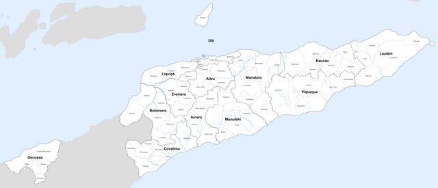
Deutsch: Karte von Osttimor mit den administrativen Grenzen seit 2015
English: Map of East Timor with the new administrative borders since 2015 |
| Date | see file history |
| Source | Own work using: information from the Ministério da Administração Estatal with maps (click 'Serviços' > 'Administração Municipal' and then choose the Município and the Posto Administrativo you want) |
| Author | Maximilian Dörrbecker (Chumwa) |
| Permission (Reusing this file) |
I, the copyright holder of this work, hereby publish it under the following license: This file is licensed under the Creative Commons Attribution-Share Alike 2.5 Generic license.
Sie dürfen das Bild zu den folgenden Bedingungen nutzen:
|
File history
Click on a date/time to view the file as it appeared at that time.
| Date/Time | Thumbnail | Dimensions | User | Comment | |
|---|---|---|---|---|---|
| current | 19:22, 19 October 2017 | | 7,328 × 3,151 (1.11 MB) | Chumwa (talk | contribs) | |
| 20:09, 14 October 2017 |  | 7,328 × 3,151 (1.11 MB) | Chumwa (talk | contribs) | == {{int:filedesc}} == {{Information | Description = {{de|1=Karte von Osttimor mit den administrativen Grenzen seit 2015}} {{en|1=Map of East Timor with the new administrative borders since 2015}} |Source = {{own using}} information from the [... |
You cannot overwrite this file.
File usage on Commons
The following 3 pages use this file:
_-_th_-_colored.svg)
_-_Munic%C3%ADpios_and_Subdistritos_(with_names).png&redirect=no)
File usage on other wikis
The following other wikis use this file:
- Usage on de.wikipedia.org
- Usage on id.wikipedia.org
- Usage on km.wikipedia.org
_-_Municípios_and_Posto_Administrativos_(with_names).png&oldid=648634320)