File:Map of Lithuania and Poland c. 1400.jpg
Jump to navigation
Jump to search
No higher resolution available.
Map_of_Lithuania_and_Poland_c._1400.jpg (574 × 475 pixels, file size: 38 KB, MIME type: image/jpeg)
Captions
Captions
Add a one-line explanation of what this file represents
Summary
[edit]
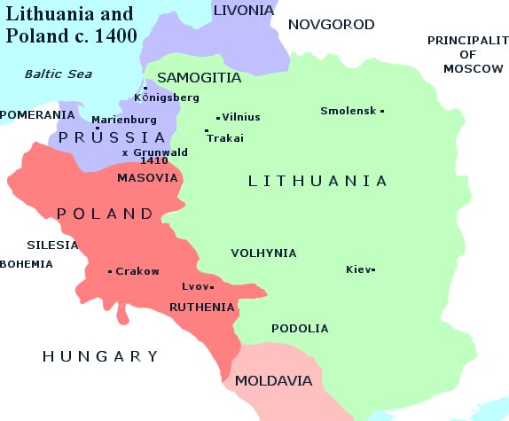
| Description | Map of Lithuania and Poland, c.1400. Information taken mainly from the old German Map Image:Poland under Jagello.jpg, plus a few locations from a map in the book The Times Concise Atlas of World History, ISBN 0723006741. |
| Date | |
| Source | Old German Map Image:Poland under Jagello.jpg, plus a few locations from a map in the book The Times Concise Atlas of World History, ISBN 0723006741. |
| Author | Qp10qp |
| Permission (Reusing this file) |
Own work. No attribution required. |
| Other versions | Derivative works of this file: Map of Lithuania and Poland c. 1400 (ru).svg |
.svg)
Licensing
[edit]
| I, the copyright holder of this work, release this work into the public domain. This applies worldwide. In some countries this may not be legally possible; if so: I grant anyone the right to use this work for any purpose, without any conditions, unless such conditions are required by law. |
File history
Click on a date/time to view the file as it appeared at that time.
| Date/Time | Thumbnail | Dimensions | User | Comment | |
|---|---|---|---|---|---|
| current | 22:25, 14 January 2007 | | 574 × 475 (38 KB) | Qp10qp (talk | contribs) | {{Information| |Description=Map of Lithuania and Poland, c.1400. Information taken mainly from the old German Map Image:Poland under Jagello.jpg plus a few locations from a map in the book ''The Times Concise Atlas of World History'', ISBN 0723006741. |
You cannot overwrite this file.
File usage on Commons
The following page uses this file:
File usage on other wikis
The following other wikis use this file:
- Usage on lt.wikipedia.org
- Usage on lt.wikibooks.org
- Usage on vi.wikipedia.org