File:Map of Land Ceded by Treaty of Fort Jackson.png
Jump to navigation
Jump to search
No higher resolution available.
Map_of_Land_Ceded_by_Treaty_of_Fort_Jackson.png (320 × 336 pixels, file size: 25 KB, MIME type: image/png)
Captions
Captions
Add a one-line explanation of what this file represents

|
This map image could be re-created using vector graphics as an SVG file. This has several advantages; see Commons:Media for cleanup for more information. If an SVG form of this image is available, please upload it and afterwards replace this template with
{{vector version available|new image name}}.
It is recommended to name the SVG file “Map of Land Ceded by Treaty of Fort Jackson.svg”—then the template Vector version available (or Vva) does not need the new image name parameter. |
Summary
[edit]
| Description |
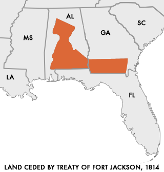
English: Map of Land Ceded to the United States by the warring Creek Nations in the Treaty of Fort Jackson of 1814.
User:Dystopos created this map using as reference a map "Creek Land Cessions Map 1733 through 1832" from the Horseshoe Bend National Military Park page on Areaparks.com [1] Polski: Mapa ziem scedowanych na rzecz USA przez Naród Krików na mocy Traktatu z Fort Jackson z 1814 roku |
| Date | (upload to english Wikipedia) |
| Source | http://en.wikipedia.org/wiki/Image:Map_of_Land_Ceded_by_Treaty_of_Fort_Jackson.png |
| Author | User:Dystopos |
| Permission (Reusing this file) |
No Rights Reserved |
Licensing
[edit]
| This work has been released into the public domain by its author, Dystopos. This applies worldwide. In some countries this may not be legally possible; if so: |
File history
Click on a date/time to view the file as it appeared at that time.
| Date/Time | Thumbnail | Dimensions | User | Comment | |
|---|---|---|---|---|---|
| current | 14:48, 28 March 2006 | | 320 × 336 (25 KB) | Cień (talk | contribs) | {{Information| |Description=Map of Land Ceded to the United States by the warring Creek Nations in the Treaty of Fort Jackson of 1814. I created this map using as reference a map "Creek Land Cessions Map 1733 through 1832" from the Horseshoe Bend |
You cannot overwrite this file.
File usage on Commons
The following page uses this file:
File usage on other wikis
The following other wikis use this file:
- Usage on ar.wikipedia.org
- Usage on be.wikipedia.org
- Usage on ca.wikipedia.org
- Usage on da.wikipedia.org
- Usage on de.wikipedia.org
- Usage on en.wikipedia.org
- Usage on es.wikipedia.org
- Usage on fi.wikipedia.org
- Usage on fr.wikipedia.org
- Usage on it.wikipedia.org
- Usage on ja.wikipedia.org
- Usage on pl.wikipedia.org
- Usage on pt.wikipedia.org
- Usage on ro.wikipedia.org
- Usage on ru.wikipedia.org
- Usage on sr.wikipedia.org
- Usage on sv.wikipedia.org
- Usage on tr.wikipedia.org
- Usage on vi.wikipedia.org
- Usage on www.wikidata.org
- Usage on zh.wikipedia.org