File:Map of Klondike gold fields, 1898 (AL+CA 785).jpg

Original file (768 × 630 pixels, file size: 95 KB, MIME type: image/jpeg)
Captions
Captions
Summary
[edit].jpg&action=edit§ion=1)
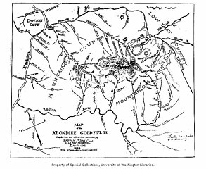
| English: Map of Klondike gold fields, 1898
( |
||||||||||||||||||||||||
|---|---|---|---|---|---|---|---|---|---|---|---|---|---|---|---|---|---|---|---|---|---|---|---|---|
| Photographer |
Unknown author |
|||||||||||||||||||||||
| Title |
English: Map of Klondike gold fields, 1898 |
|||||||||||||||||||||||
| Description |
English: Caption on image: Map of the Klondike Goldfields, compiled from best information obtainable, by Tappan Adney and E. LeRoy Pelletier. Dawson, 1898. (Drawn by Tappan Adney -- copyright applied for). Filed in Yukon Territory It all began with Robert Henderson, a fur trapper and part-time prospector who, in 1894, found gold in Rabbit Creek (later renamed Bonanza) not far from where the Klondike River empties into the Yukon. When he had prospected this clear, shallow stream, he was certain he was close to a major find. Two years passed, however, before he could persuade his friend, George Washington Carmack, to go into the area. Carmack and his native companions, Dawson Charley and Skookum Jim, explored the area around the river the Indians called "Tr'ondek"—or Klondike to English tongues. The three lucky prospectors discovered gold on Bonanza Creek on August 17, 1896. A short time later, at the nearby mining camp of Fortymile, Carmack registered the discovery claim. Within days, Bonanza and Eldorado creeks had been staked from end to end. Carmack forgot to tell poor Henderson, who missed out entirely on the richest claims. Thirty thousand (some say fifty) pick-and-shovel miners, prospectors, storekeepers, saloon keepers, bankers, gamblers, prostitutes and con men from every corner of the continent poured through snow-choked mountain passes and down the Yukon River to stake their claim to fortune on creeks with names like Eldorado, Bonanza, Last Chance and Too Much Gold. Most seekers found no gold at all. But the prospect of sudden riches was not all that mattered. For many of those who made the incredible journey, the Klondike represented escape from the humdrum, the adventure of a new frontier.
|
|||||||||||||||||||||||
| Depicted place | Yukon | |||||||||||||||||||||||
| Date | 1898 | |||||||||||||||||||||||
| Collection |
|
|||||||||||||||||||||||
| Current location | ||||||||||||||||||||||||
| Accession number | ||||||||||||||||||||||||
| Source | ||||||||||||||||||||||||
| Permission (Reusing this file) |
|
|||||||||||||||||||||||
| Order Number | AWC0869 | |||||||||||||||||||||||
File history
Click on a date/time to view the file as it appeared at that time.
| Date/Time | Thumbnail | Dimensions | User | Comment | |
|---|---|---|---|---|---|
| current | 21:18, 30 March 2019 | | 768 × 630 (95 KB) | BMacZeroBot (talk | contribs) | (BOT) batch upload |
You cannot overwrite this file.
File usage on Commons
The following page uses this file:
.jpg)
File usage on other wikis
The following other wikis use this file:
- Usage on de.wikipedia.org
.jpg&oldid=690318624)