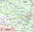
File:Map of Kharta region, east of Mount Everest.svg

Original file (SVG file, nominally 1,279 × 1,194 pixels, file size: 464 KB)
Captions
Captions
Summary
[edit]| DescriptionMap of Kharta region, east of Mount Everest.svg |
English: Sketch map of w:Kharta and Kama velleys and environs, east of Mount Everest
The information on the map comes from
File:Preliminary map of Mount Everest Expedition, 1921. Map I.jpg and
|
| Date | |
| Source | Own work |
| Author | Thincat |
Licensing
[edit]- You are free:
- to share – to copy, distribute and transmit the work
- to remix – to adapt the work
- Under the following conditions:
- attribution – You must give appropriate credit, provide a link to the license, and indicate if changes were made. You may do so in any reasonable manner, but not in any way that suggests the licensor endorses you or your use.
- share alike – If you remix, transform, or build upon the material, you must distribute your contributions under the same or compatible license as the original.
File history
Click on a date/time to view the file as it appeared at that time.
| Date/Time | Thumbnail | Dimensions | User | Comment | |
|---|---|---|---|---|---|
| current | 19:31, 26 August 2014 |  | 1,279 × 1,194 (464 KB) | Thincat (talk | contribs) | 1921 Everest reconnaissance routes and example trekking route shown |
| 23:11, 25 August 2014 |  | 1,279 × 1,194 (451 KB) | Thincat (talk | contribs) | Minor additions and corrections | |
| 16:19, 25 August 2014 |  | 1,279 × 1,194 (422 KB) | Thincat (talk | contribs) | Lumeh, Kangchungtse (Makalu II), ... | |
| 10:18, 25 August 2014 |  | 1,279 × 1,194 (420 KB) | Thincat (talk | contribs) | Extended north | |
| 23:51, 24 August 2014 |  | 1,280 × 718 (105 KB) | Thincat (talk | contribs) | Les violent colours | |
| 23:30, 24 August 2014 |  | 1,280 × 718 (105 KB) | Thincat (talk | contribs) | Add Rongbuk Glacier, etc. | |
| 22:45, 24 August 2014 |  | 1,280 × 718 (102 KB) | Thincat (talk | contribs) | More tidying | |
| 20:08, 24 August 2014 |  | 1,213 × 713 (93 KB) | Thincat (talk | contribs) | Slight tidy | |
| 19:30, 24 August 2014 |  | 1,213 × 713 (89 KB) | Thincat (talk | contribs) | Crop | |
| 19:25, 24 August 2014 |  | 1,231 × 844 (87 KB) | Thincat (talk | contribs) | Various. Continuing Kharta Chu, etc |
You cannot overwrite this file.
File usage on Commons
There are no pages that use this file.
File usage on other wikis
The following other wikis use this file:
- Usage on de.wikipedia.org
- Usage on en.wikipedia.org
- Usage on hi.wikipedia.org
- Usage on it.wikipedia.org
- Usage on pa.wikipedia.org
- Usage on zh.wikipedia.org
Metadata
This file contains additional information such as Exif metadata which may have been added by the digital camera, scanner, or software program used to create or digitize it. If the file has been modified from its original state, some details such as the timestamp may not fully reflect those of the original file. The timestamp is only as accurate as the clock in the camera, and it may be completely wrong.
| Width | 1278.9465 |
|---|---|
| Height | 1194.3397 |