File:Map of Hohenlohekreis.png
Jump to navigation
Jump to search
No higher resolution available.
Map_of_Hohenlohekreis.png (505 × 502 pixels, file size: 22 KB, MIME type: image/png)
Captions
Captions
Add a one-line explanation of what this file represents
Summary
[edit]
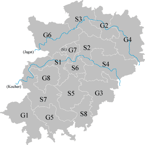
| Description | A Map of Hohenlohekreis, Baden-Württemberg, Germany. "S" means "Städe", S1; Forchtenberg, S2; Ingelfingen, S3; Krautheim, S4; Künzelsau, S5; Neuenstein, S6; Niedernhall, S7; Öhringen, S8; Waldenburg. "G" means "Gemeinden", G1; Bretzfeld, G2; Dörzbach, G3; Kupferzell, G4; Mulfingen, G5; Pfedelbach, G6; Schöntal, G7; Weißbach, G8; Zweiflingen. |
| Date | |
| Source | Own work |
| Author | User:汲平 |
Licensing
[edit]

|
Permission is granted to copy, distribute and/or modify this document under the terms of the GNU Free Documentation License, Version 1.2 or any later version published by the Free Software Foundation; with no Invariant Sections, no Front-Cover Texts, and no Back-Cover Texts. A copy of the license is included in the section entitled GNU Free Documentation License. |
| This file is licensed under the Creative Commons Attribution-Share Alike 3.0 Unported license. | ||
| ||
| This licensing tag was added to this file as part of the GFDL licensing update. |
File history
Click on a date/time to view the file as it appeared at that time.
| Date/Time | Thumbnail | Dimensions | User | Comment | |
|---|---|---|---|---|---|
| current | 07:02, 11 August 2007 | | 505 × 502 (22 KB) | 汲平 (talk | contribs) | {{Information |Description=A Map of Landkreis Ansbach, Bayern, Germany. "S" means "Städe", S1; Forchtenberg, S2; Ingelfingen, S3; Krautheim, S4; Künzelsau, S5; Neuenstein, S6; Niedernhall, S7; Öhringen, S8; Waldenburg. "G" means "Gemeinden", G1; Bretzf |
| 06:57, 11 August 2007 |  | 505 × 502 (22 KB) | 汲平 (talk | contribs) | {{Information |Description=A Map of Landkreis Ansbach, Bayern, Germany. "S" means "Städe", S1; Forchtenberg, S2; Ingelfingen, S3; Krautheim, S4; Künzelsau, S5; Neuenstein, S6; Niedernhall, S7; Öhringen, S8; Waldenburg. "G" means "Gemeinden", G1; Bretzf |
You cannot overwrite this file.
File usage on Commons
The following page uses this file: