File:Map of Banat of Temeswar by Castulus Riedl.jpg

Original file (8,550 × 9,876 pixels, file size: 14.2 MB, MIME type: image/jpeg)
Captions
Captions
Summary
[edit]| Warning | The original file is very high-resolution. It might not load properly or could cause your browser to freeze when opened at full size. |
|---|
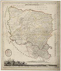
| Johann Michael Mettenleiter: Karte von dem Banat Temeswar und einigen Districten auf servischer Seite
( |
||||||||||||||||||||||||||||||||||||||
|---|---|---|---|---|---|---|---|---|---|---|---|---|---|---|---|---|---|---|---|---|---|---|---|---|---|---|---|---|---|---|---|---|---|---|---|---|---|---|
| Artist |
engraver:
|
|||||||||||||||||||||||||||||||||||||
| Author |
after cartographer:
|
|||||||||||||||||||||||||||||||||||||
| Title |
Karte von dem Banat Temeswar und einigen Districten auf servischer Seite |
|||||||||||||||||||||||||||||||||||||
| Description |
English: Map of Banat of Temeswar by Castulus Riedl.
Deutsch: Karte von dem Banat Temeswar und einigen Districten auf servischer Seite. Geographisch aufgenommen von Castulus Riedl. K: Palz Bayr: Ingen: Capit ; Gestochen von M. Mettenleitter in der Direct. des J. G. Wintter in München 1789. |
|||||||||||||||||||||||||||||||||||||
| Date | 1789 | |||||||||||||||||||||||||||||||||||||
| Dimensions | height: 58 cm (22.8 in); width: 50 cm (19.6 in) | |||||||||||||||||||||||||||||||||||||
| Collection |
|
|||||||||||||||||||||||||||||||||||||
| References |
|
|||||||||||||||||||||||||||||||||||||
| Source/Photographer |
Français : Bibliothèque nationale de France, GED-7542 |
|||||||||||||||||||||||||||||||||||||
| Permission (Reusing this file) |
|
|||||||||||||||||||||||||||||||||||||


Licensing
[edit]
|
The author died in 1853, so this work is in the public domain in its country of origin and other countries and areas where the copyright term is the author's life plus 100 years or fewer. This work is in the public domain in the United States because it was published (or registered with the U.S. Copyright Office) before January 1, 1929. | |
| This file has been identified as being free of known restrictions under copyright law, including all related and neighboring rights. | |
File history
Click on a date/time to view the file as it appeared at that time.
| Date/Time | Thumbnail | Dimensions | User | Comment | |
|---|---|---|---|---|---|
| current | 09:20, 12 June 2023 | | 8,550 × 9,876 (14.2 MB) | Trauenbaum (talk | contribs) | Uploaded a work by Castulus Riedl, Johann Michael Mettenleitter, Joseph Georg Winter from Karte von dem Banat Temeswar und einigen Districten auf servischer Seite – Geographii. aufgenommen von Castulus Riedl K: Palz Bayr: Ingen: Capit ; Gestochen von M. Mettenleitter in der Direct. des J. G. Wintter in München 1789. Bibliothèque nationale de France, GED-420 with UploadWizard |
You cannot overwrite this file.
File usage on Commons
The following 2 pages use this file: