File:Map indicating Coronation Gulf, Nunavut, Canada.png
Jump to navigation
Jump to search
No higher resolution available.
Map_indicating_Coronation_Gulf,_Nunavut,_Canada.png (415 × 370 pixels, file size: 65 KB, MIME type: image/png)
Captions
Captions
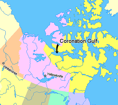
Location map of Coronation Gulf
Summary
[edit]
Map indicating Coronation Gulf, Nunavut, Canada.
Nunavut
Northwest Territories
Yukon Territory
British Columbia
Alberta
Saskatchewan
Manitoba
Regions outside Canada (Greenland, Alaska)
© Her Majesty the Queen in Right of Canada, Department of Natural Resources. All rights reserved.
Licence Agreement
Licensing
[edit]

|
The copyright holder of this work allows anyone to use it for any purpose including unrestricted redistribution, commercial use, and modification.
Usage notes:
|
File history
Click on a date/time to view the file as it appeared at that time.
| Date/Time | Thumbnail | Dimensions | User | Comment | |
|---|---|---|---|---|---|
| current | 04:01, 21 March 2006 | | 415 × 370 (65 KB) | David Kernow~commonswiki (talk | contribs) | Map indicating Coronation Gulf, Nunavut, Canada. {{legend|#ffff66|Nunavut}} {{legend|#ffccff|Northwest Territories}} {{legend|#ffcc99|Yukon Territory}} {{legend|#ffff99|British Columbia}} {{legend|#cccc99|Alberta}} {{legend|#99ffcc| |
You cannot overwrite this file.
File usage on Commons
There are no pages that use this file.
File usage on other wikis
The following other wikis use this file:
- Usage on ar.wikipedia.org
- Usage on ckb.wikipedia.org
- Usage on de.wikipedia.org
- Usage on en.wikipedia.org
- Usage on en.wiktionary.org
- Usage on es.wikipedia.org
- Usage on et.wikipedia.org
- Usage on fa.wikipedia.org
- Usage on fi.wikipedia.org
- Usage on fr.wikipedia.org
- Usage on ja.wikipedia.org
- Usage on ml.wikipedia.org
- Usage on nl.wikipedia.org