File:Map France 1477-es.svg

Original file (SVG file, nominally 900 × 970 pixels, file size: 1.53 MB)
Captions
Captions
Summary
[edit]| Description |
Català: Mapa de França el 1477.
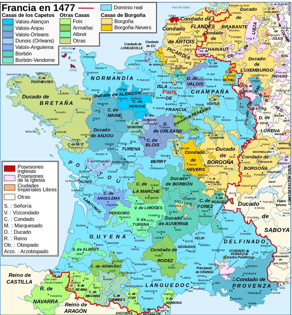
Español: Mapa de Francia en 1477.
English: Map of the France in 1477. |
||||||||
| Date | |||||||||
| Source |
Español: Creación personal. Datos:
English: Own work. Image renamed from Image:Map France History XVe.svg. Data:
|
||||||||
| Author | Orror (French original); Molorco (Spanish translation) | ||||||||
| Permission (Reusing this file) |
I, the copyright holder of this work, hereby publish it under the following licenses:
This file is licensed under the Creative Commons Attribution-Share Alike 2.5 Generic license.
You may select the license of your choice. |
||||||||
| Other versions |
File:Map France 1477-es.svg has 2 translations.
Other related versions: []
|


|
This SVG file contains embedded text that can be translated into your language, using any capable SVG editor, text editor or the SVG Translate tool. For more information see: About translating SVG files. |
This file is translated using SVG <switch> elements. All translations are stored in the same file! Learn more.
For most Wikipedia projects, you can embed the file normally (without a To translate the text into your language, you can use the SVG Translate tool. Alternatively, you can download the file to your computer, add your translations using whatever software you're familiar with, and re-upload it with the same name. You will find help in Graphics Lab if you're not sure how to do this. |
File history
Click on a date/time to view the file as it appeared at that time.
| Date/Time | Thumbnail | Dimensions | User | Comment | |
|---|---|---|---|---|---|
| current | 02:10, 28 May 2024 | | 900 × 970 (1.53 MB) | Manlleus (talk | contribs) | File uploaded using svgtranslate tool (https://svgtranslate.toolforge.org/). Added translation for ca. |
| 00:14, 14 December 2007 |  | 900 × 970 (1.23 MB) | Molorco (talk | contribs) | {{Information |Description=Mapa de Francia en 1477. |Source=Creación personal a partir de Image:Map_France_1477-fr.svg |Date=2007-12-14 |Author=Molorco |Permission= |other_versions= }} |
You cannot overwrite this file.
File usage on Commons
The following 10 pages use this file:
- User:Magog the Ogre/Multilingual legend/2024 May 27-31
- File:Map France 1477-br.svg
- File:Map France 1477-de.svg
- File:Map France 1477-en.svg
- File:Map France 1477-es.svg
- File:Map France 1477-fr.svg
- File:Map France 1477-ru.svg
- File:Map France 1477-uk.svg
- File:Pays de Retz.jpg
- Template:Other versions/Map France 1477
File usage on other wikis
The following other wikis use this file:
- Usage on ast.wikipedia.org
- Usage on ca.wikipedia.org
- Usage on es.wikipedia.org
- Historia de Francia
- Guerra de los Cien Años
- Condado de Foix
- Borgoña
- Francia en la Edad Media
- Antiguo Régimen
- Guyena
- Historia de Navarra
- Discusión:Historia de Navarra
- Ducado de Borgoña
- Cominges
- Anexo:Dominios de los reyes de Navarra Albret-Foix
- Alano de Albret
- Bigorra
- Estado borgoñón
- Pedro González de Mendoza (cardenal)
- Asedio de Dijon
- Francia en la Edad Moderna
- Historia de Occitania
- Historia de Borgoña
- Historia de Provenza
- Tierras de la Corona de Francia
- Angoumois
- Casa de Albret
- Limosín (provincia)
- Ducado de Nemours
- Usage on eu.wikipedia.org
- Usage on gl.wikipedia.org
- Usage on io.wikipedia.org
- Usage on pt.wikipedia.org
- Usage on www.wikidata.org