File:Malawi district map 2020.svg
Jump to navigation
Jump to search

Size of this PNG preview of this SVG file: 545 × 600 pixels. Other resolutions: 218 × 240 pixels | 436 × 480 pixels | 698 × 768 pixels | 931 × 1,024 pixels | 1,862 × 2,048 pixels | 639 × 703 pixels.
Original file (SVG file, nominally 639 × 703 pixels, file size: 1.4 MB)
Captions
Captions
Add a one-line explanation of what this file represents
Summary
[edit]| Description |
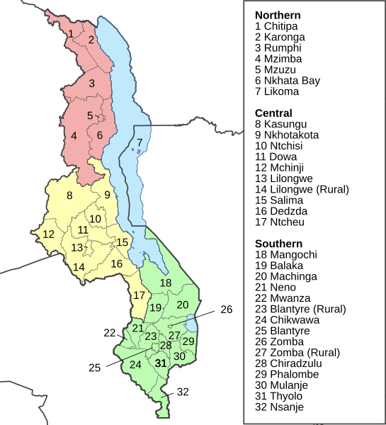
Deutsch: Distriktkarte von Malawi (Stand 2020).
English: District map of Malawi (as of 2020). |
||
| Date | |||
| Source | various maps from OCHA | ||
| Author | Furfur | ||
| Permission (Reusing this file) |
I, the copyright holder of this work, hereby publish it under the following licenses:
This file is licensed under the Creative Commons Attribution-Share Alike 4.0 International license.
You may select the license of your choice. |
||
| SVG development | This map was created with Adobe Illustrator. |

File history
Click on a date/time to view the file as it appeared at that time.
| Date/Time | Thumbnail | Dimensions | User | Comment | |
|---|---|---|---|---|---|
| current | 12:17, 23 May 2021 | | 639 × 703 (1.4 MB) | Furfur (talk | contribs) | Korrektur |
| 10:59, 23 May 2021 |  | 639 × 703 (1.4 MB) | Furfur (talk | contribs) | == {{int:filedesc}} == {{Information |Description={{User:Medium69/Traduction}} {{de|1=Distriktkarte von Malawi (Stand 2020).}} {{en|1=District map of Malawi (as of 2020).}} |Source=various aps from [https://data.humdata.org/ OCHA] |Date=2021-05-23 |Author={{U|Furfur}} |Permission={{self|GFDL|cc-by-sa-4.0}} |Other versions= |Other fields={{Igen|A|+|%|s=m}} }} Category:Locator maps of districts of Malawi Category:SVG maps of Malawi |
You cannot overwrite this file.
File usage on Commons
The following 2 pages use this file:
- File:MW-Districts.svg
- File:Malawi district map 2020 de.svg (file redirect)
File usage on other wikis
The following other wikis use this file:
- Usage on cs.wikipedia.org
- Usage on de.wikipedia.org