File:Lydia Leister Barn, Taneytown Road (State Route 134) and Hunt Avenue, Gettysburg, Adams County, PA HABS PA,1-GET.V,1A- (sheet 5 of 8).tif
Jump to navigation
Jump to search

Size of this JPG preview of this TIF file: 800 × 533 pixels. Other resolutions: 320 × 213 pixels | 640 × 427 pixels | 1,024 × 682 pixels | 1,280 × 853 pixels | 2,560 × 1,706 pixels | 14,452 × 9,632 pixels.
Original file (14,452 × 9,632 pixels, file size: 731 KB, MIME type: image/tiff)
Captions
Captions
Add a one-line explanation of what this file represents
Summary
[edit]| Warning | The original file is very high-resolution. It might not load properly or could cause your browser to freeze when opened at full size. |
|---|
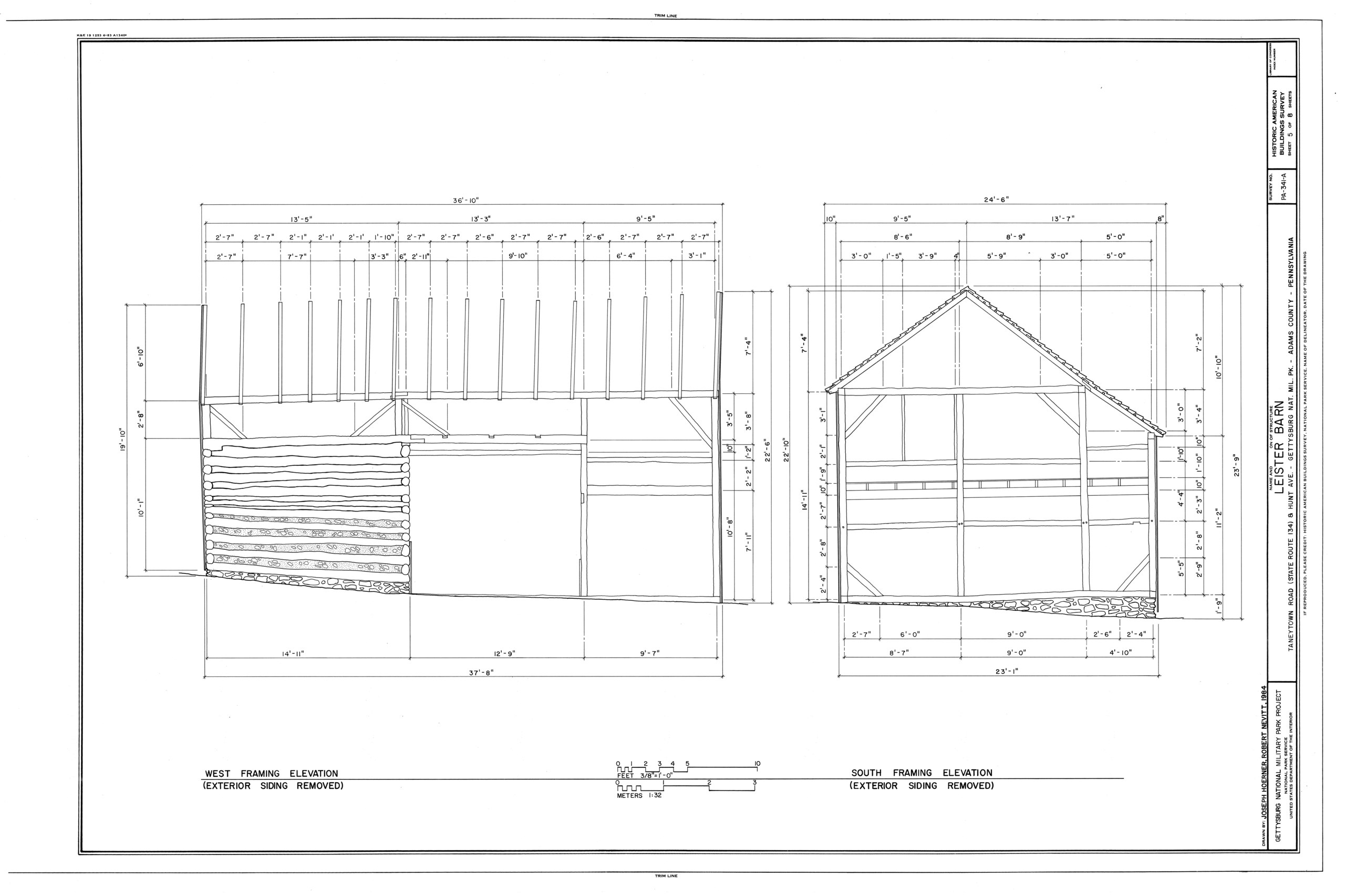
| HABS PA,1-GET.V,1A- (sheet 5 of 8) - Lydia Leister Barn, Taneytown Road (State Route 134) and Hunt Avenue, Gettysburg, Adams County, PA | ||||
|---|---|---|---|---|
| Title |
HABS PA,1-GET.V,1A- (sheet 5 of 8) - Lydia Leister Barn, Taneytown Road (State Route 134) and Hunt Avenue, Gettysburg, Adams County, PA |
|||
| Description |
Bishop, Henry; Leister, Lydia; Meade, George Gordon; Heiser, John S, field team; Anderson, Kenneth L, project manager; Engle, Reed, delineator; Hoerner, Joseph M, delineator; Nevitt, Robert D, delineator |
|||
| Depicted place | Pennsylvania; Adams County; Gettysburg | |||
| Date | Documentation compiled after 1933 | |||
| Dimensions | 24 x 36 in. (D size) | |||
| Current location |
Library of Congress Prints and Photographs Division Washington, D.C. 20540 USA http://hdl.loc.gov/loc.pnp/pp.print |
|||
| Accession number |
HABS PA,1-GET.V,1A- (sheet 5 of 8) |
|||
| Credit line |
|
|||
| Notes |
|
|||
| Source | https://www.loc.gov/pictures/item/pa1413.sheet.00005a | |||
| Permission (Reusing this file) |
|
|||

| Object location | | View this and other nearby images on: OpenStreetMap |
|---|
File history
Click on a date/time to view the file as it appeared at that time.
| Date/Time | Thumbnail | Dimensions | User | Comment | |
|---|---|---|---|---|---|
| current | 11:12, 30 July 2014 |  | 14,452 × 9,632 (731 KB) | Fæ (talk | contribs) | GWToolset: Creating mediafile for Fæ. HABS 30 July 2014 (2901:3000) |
You cannot overwrite this file.
File usage on Commons
The following page uses this file: