File:Lorraine et anciennes provinces.svg

Original file (SVG file, nominally 3,055 × 2,977 pixels, file size: 1.24 MB)
Captions
Captions
Summary
[edit]
| Description |
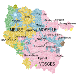
English: Map showing the French region of Lorraine and the former States and provinces that existed in the 18th century.
Français : Carte de la région Lorraine montrant les Etats et provinces existant au XVIIIe siècle.
|
||||
| Date | |||||
| Source |
Carte de la Lorraine et du Barrois dans laquelle se trouvent la Généralité de Metz et autres enclaves, Dressée pour la lecture du Mémoire de M. Durival l'ainé et dédiée au Roy de Pologne Duc de Lorraine et de Bar, Robert de Vaugondy, 1756. Derivative works of this file: Blank Map of Meuse Department, France, with Communes.svg by Poulpy Derivative works of this file: Blank Map of Vosges Department, France, with Communes.svg by Poulpy Derivative works of this file: Blank Map of Meurthe-et-Moselle Department, France, with Communes.svg by Poulpy Derivative works of this file: Blank Map of Moselle Department, France, with Communes.svg by Poulpy |
||||
| Author | Oie blanche |
Licensing
[edit]
- You are free:
- to share – to copy, distribute and transmit the work
- to remix – to adapt the work
- Under the following conditions:
- attribution – You must give appropriate credit, provide a link to the license, and indicate if changes were made. You may do so in any reasonable manner, but not in any way that suggests the licensor endorses you or your use.
- share alike – If you remix, transform, or build upon the material, you must distribute your contributions under the same or compatible license as the original.
File history
Click on a date/time to view the file as it appeared at that time.
| Date/Time | Thumbnail | Dimensions | User | Comment | |
|---|---|---|---|---|---|
| current | 16:52, 5 December 2013 | | 3,055 × 2,977 (1.24 MB) | Oie blanche (talk | contribs) | User created page with UploadWizard |
You cannot overwrite this file.
File usage on Commons
There are no pages that use this file.
File usage on other wikis
The following other wikis use this file:
- Usage on el.wikipedia.org
- Usage on en.wikipedia.org
- Usage on fr.wikipedia.org
- Usage on ko.wikipedia.org
- Usage on la.wikipedia.org
- Usage on sl.wikipedia.org
- Usage on vi.wikipedia.org