File:Location map of Maine, France.svg
Jump to navigation
Jump to search

Size of this PNG preview of this SVG file: 800 × 561 pixels. Other resolutions: 320 × 224 pixels | 640 × 448 pixels | 1,024 × 718 pixels | 1,280 × 897 pixels | 2,560 × 1,794 pixels | 3,007 × 2,107 pixels.
Original file (SVG file, nominally 3,007 × 2,107 pixels, file size: 260 KB)
Captions
Captions
Add a one-line explanation of what this file represents
Summary
[edit]
| Description |
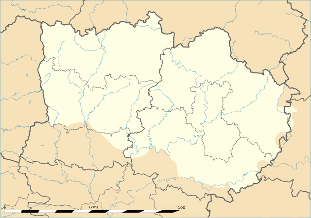
English: Map of the province of Maine, France, with the modern administrative limits of Mayenne and Sarthe departments. Français : Carte du Maine, France, avec les limites administratives modernes de la Mayenne et de la Sarthe. |
| Date | |
| Source | Eric Gaba (Sting - fr:Sting) (Media:Pays de la Loire region location map.svg) for the map model. For the limits of Maine: Guillaume Delisle, 1779 : Carte des Provinces du Maine et du Perche. |
| Author | Oie blanche |
Licensing
[edit]
I, the copyright holder of this work, hereby publish it under the following license:
This file is licensed under the Creative Commons Attribution-Share Alike 3.0 Unported license.
- You are free:
- to share – to copy, distribute and transmit the work
- to remix – to adapt the work
- Under the following conditions:
- attribution – You must give appropriate credit, provide a link to the license, and indicate if changes were made. You may do so in any reasonable manner, but not in any way that suggests the licensor endorses you or your use.
- share alike – If you remix, transform, or build upon the material, you must distribute your contributions under the same or compatible license as the original.
File history
Click on a date/time to view the file as it appeared at that time.
| Date/Time | Thumbnail | Dimensions | User | Comment | |
|---|---|---|---|---|---|
| current | 17:14, 12 April 2013 | | 3,007 × 2,107 (260 KB) | Oie blanche (talk | contribs) | User created page with UploadWizard |
You cannot overwrite this file.
File usage on Commons
There are no pages that use this file.
File usage on other wikis
The following other wikis use this file:
- Usage on eo.wikipedia.org
- Usage on fr.wikipedia.org
- Usage on ru.wikipedia.org