File:Lexington-Fayette-Frankfort-Richmond CSA.png
Jump to navigation
Jump to search
No higher resolution available.
Lexington-Fayette-Frankfort-Richmond_CSA.png (651 × 291 pixels, file size: 35 KB, MIME type: image/png)
Captions
Captions
Add a one-line explanation of what this file represents
| Description |
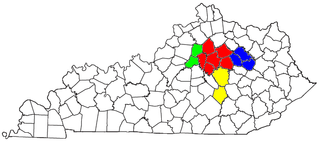
Locator map of the Lexington-Fayette-Frankfort-Richmond Combined Statistical Area in the central part of the U.S. state of Kentucky. The five components of the CSA are colored separately: |
||
| Date | |||
| Source |
Modified from this United States Census Bureau file, based on the following Census definitions lists: |
||
| Author | User:Nyttend | ||
| Permission (Reusing this file) |
US Government work is public domain, and my work is
|
File history
Click on a date/time to view the file as it appeared at that time.
| Date/Time | Thumbnail | Dimensions | User | Comment | |
|---|---|---|---|---|---|
| current | 13:18, 30 July 2008 | | 651 × 291 (35 KB) | Nyttend (talk | contribs) | {{Information |Description=Locator map of the {{w|Lexington-Fayette-Frankfort-Richmond, KY Combined Statistical Area|Lexington-Fayette-Frankfort-Richmond}} {{w|Combined Statistical Area}} in the central part of the {{w|U.S. state}} of {{w|Kentucky}}. The |
You cannot overwrite this file.
File usage on Commons
There are no pages that use this file.
File usage on other wikis
The following other wikis use this file:
- Usage on en.wikipedia.org
- Usage on es.wikipedia.org
- Usage on fa.wikipedia.org
- Usage on sh.wikipedia.org
- Usage on tr.wikipedia.org
- Usage on ur.wikipedia.org
- Usage on www.wikidata.org
Categories:
- Maps of census statistical areas in Kentucky
- Maps of Anderson County, Kentucky
- Maps of Bath County, Kentucky
- Maps of Bourbon County, Kentucky
- Maps of Clark County, Kentucky
- Maps of Fayette County, Kentucky
- Maps of Franklin County, Kentucky
- Maps of Jessamine County, Kentucky
- Maps of Madison County, Kentucky
- Maps of Menifee County, Kentucky
- Maps of Montgomery County, Kentucky
- Maps of Rockcastle County, Kentucky
- Maps of Scott County, Kentucky
- Maps of Woodford County, Kentucky