File:Lechaeum-it.svg
Jump to navigation
Jump to search

Size of this PNG preview of this SVG file: 398 × 304 pixels. Other resolutions: 314 × 240 pixels | 629 × 480 pixels | 1,006 × 768 pixels | 1,280 × 978 pixels | 2,560 × 1,955 pixels.
Original file (SVG file, nominally 398 × 304 pixels, file size: 143 KB)
Captions
Captions
Add a one-line explanation of what this file represents
Summary
[edit]
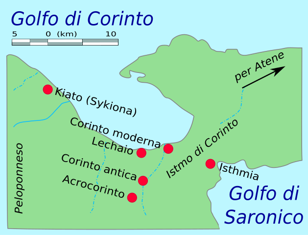
| Description | Map of area around ancient Lecaheum, near Corinth. The Corinthian Canal has been erased from the map. |
| Date | (UTC) |
| Source |
This file was derived from: Lechaeum-es.svg: |
| Author |
|
| This is a retouched picture, which means that it has been digitally altered from its original version. Modifications: Italian translation. The original can be viewed here: Lechaeum-es.svg:
|
Licensing
[edit]
I, the copyright holder of this work, hereby publish it under the following licenses:
This image is in the public domain because it came from the site https://www.demis.nl/products/web-map-server/examples/ and was released by the copyright holder. Permission is granted to copy, distribute and/or modify this map since it is based on free of copyright images from: www.demis.nl. See also approval email on de.wp and its clarification.
|
| This work has been released into the public domain by its copyright holder, www.demis.nl. This applies worldwide. In some countries this may not be legally possible; if so: www.demis.nl grants anyone the right to use this work for any purpose, without any conditions, unless such conditions are required by law.
|
| I, the copyright holder of this work, release this work into the public domain. This applies worldwide. In some countries this may not be legally possible; if so: I grant anyone the right to use this work for any purpose, without any conditions, unless such conditions are required by law. |
You may select the license of your choice.
Original upload log
[edit]
This image is a derivative work of the following images:
- File:Lechaeum-es.svg licensed with PD-Demis, PD-self
- 2008-06-16T23:54:55Z Mushii 355x274 (28662 Bytes) {{Information |Description=Second try |Source= |Date= |Author= |Permission= |other_versions= }}
- 2008-06-16T23:53:02Z Mushii 355x274 (28662 Bytes) {{Information |Description=Corrected version of spanish translation by ZStardust |Source= |Date= |Author= |Permission= |other_versions= }}
- 2007-08-23T22:28:06Z ZStardust 355x274 (27902 Bytes)
- 2007-08-23T22:27:27Z ZStardust 355x274 (27902 Bytes)
- 2007-08-23T22:20:18Z ZStardust 355x274 (27902 Bytes)
- 2007-08-23T22:19:23Z ZStardust 355x274 (27898 Bytes)
- 2007-08-23T22:17:13Z ZStardust 355x274 (27898 Bytes)
- 2007-08-23T22:15:56Z ZStardust 355x274 (27896 Bytes)
- 2007-08-23T22:13:41Z ZStardust 355x274 (27904 Bytes)
- 2007-08-23T22:12:12Z ZStardust 355x274 (27905 Bytes) {{Information |Description=Map of area around ancient Lecaheum, near Corinth. The Corinthian Canal has been erased from the map. |Source=[[:Image:Lechaeum.png]] Locations were judged from a variety of sources including maps o
File history
Click on a date/time to view the file as it appeared at that time.
| Date/Time | Thumbnail | Dimensions | User | Comment | |
|---|---|---|---|---|---|
| current | 10:43, 15 October 2013 | | 398 × 304 (143 KB) | Fulvio314 (talk | contribs) | {{Information |Description=Map of area around ancient Lecaheum, near Corinth. The Corinthian Canal has been erased from the map. |Source={{Derived from|Lechaeum-es.svg|display=50}} |Date=2013-10-15 10:42 (UTC) |Author=*File:Lechaeum-es.svg: DEMIS... |
You cannot overwrite this file.
File usage on Commons
The following page uses this file:
File usage on other wikis
The following other wikis use this file: