File:Laserdaten - Stadt Hof 706 5574 - Cloud (Bayerische Vermessungsverwaltung).stl
Jump to navigation
Jump to search

Size of this PNG preview of this STL file: 800 × 600 pixels. Other resolutions: 320 × 240 pixels | 640 × 480 pixels | 1,024 × 768 pixels | 1,280 × 960 pixels | 2,560 × 1,920 pixels | 5,120 × 3,840 pixels.
Original file (5,120 × 2,880 pixels, file size: 104.93 MB, MIME type: application/sla)
Captions
Captions
Add a one-line explanation of what this file represents
Summary
[edit]| Description |
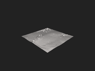
Deutsch: Mesh aus einer Point Cloud. Die Laserpunkte wurden über einen Laserscanner während einer Befliegung generiert. Hierbei tatstet ein Lasertrahl die Geländeoberfläche ab. Der Strahl wird einfach oder mehrfach reflektiert (mehrfach etwa bei Bäumen). Die erste Reflexion ist ein First-Pulse, die letzte ein Last-Pulse. Für jede Reflexion/Messpunkt werden 3D-Koordinaten (XYZ) berechnet. Die gesamte Menge ist als Ergebnis die Point-Cloud (Punktewolke). Dieses Ergebnis wird als LAZ-Datei (LiDAR Point Cloud). Leider unterstützt Commons keine LAZ-Dateien, weshalb die Datei in eine STL-Datei (Mesh) konvertiert werden. Ein Mesh besteht üblicherweise aus Vertices (Eckpunke), Edges (Kanten) und Faces (Flächen). Bei einer Point Cloud haben wir nur Vertices. Deshalb müssen Faces und Edges generiert werden. In CloudCompare wird die LAZ-Datei in eine PLY-Datei umgewandelt, die wiederum von MeshLab gelesen und verarbeitet werden kann. In MeshLab muss für die Punktmengen Normalen berechnet werden. Mit diesen lässt sich eine Oberfläche rekonstruieren. Mit "Screened Poisson" kann man das endgültige Mesh erstellen.
English: Mesh from a point cloud. The laser points were generated by a laser scanner during an aerial survey. A laser beam scans the surface of the terrain. The beam is reflected once or several times (several times for trees, for example). The first reflection is a first pulse, the last one a last pulse. For each reflection/measurement point 3D coordinates (XYZ) are calculated. The whole set is as a result the point cloud (point cloud). This result is called LAZ file (LiDAR Point Cloud). Unfortunately, Commons does not support LAZ files, so the file is converted to an STL (mesh) file. A mesh usually consists of vertices (corner points), edges (edges) and faces (faces). In a Point Cloud we only have vertices. Therefore, faces and edges must be generated. In CloudCompare, the LAZ file is converted to a PLY file, which in turn can be read and processed by MeshLab. In MeshLab, normals must be calculated for the point sets. With these, a surface can be reconstructed. With "Screened Poisson" one can create the final mesh. |
| Date | 2020s |
| Source |
|
| Author |
|
Licensing
[edit]This file is licensed under the Creative Commons Attribution 4.0 International license.
- You are free:
- to share – to copy, distribute and transmit the work
- to remix – to adapt the work
- Under the following conditions:
- attribution – You must give appropriate credit, provide a link to the license, and indicate if changes were made. You may do so in any reasonable manner, but not in any way that suggests the licensor endorses you or your use.
| The uploader of this file has agreed to the following patent warranty: Use of this file and any objects depicted in the file will not knowingly or recklessly infringe any patents. |
File history
Click on a date/time to view the file as it appeared at that time.
| Date/Time | Thumbnail | Dimensions | User | Comment | |
|---|---|---|---|---|---|
| current | 16:06, 16 September 2023 |  | 5,120 × 2,880 (104.93 MB) | PantheraLeo1359531 (talk | contribs) | Uploaded a work by * Laserpunkte (*.laz-Dateien): Bayerische Vermessungsverwaltung – www.geodaten.bayern.de * Konvertiert über *.ply (über CloudCompare v2.12.4 (Kyiv)) zu *.stl (via QGIS 3.32.0) by PantheraLeo1359531 😺 (<span class="signature-talk">{{int:Talkpagelinktext}}</span>) from * https://geodaten.bayern.de/opengeodata/OpenDataDetail.html?pn=laserdaten * https://web.archive.org/web/20230706194058/https://geodaten.bayern.de/op... |
You cannot overwrite this file.
File usage on Commons
There are no pages that use this file.