File:Lake Tai, China ESA21456724.tiff

Original file (10,980 × 10,980 pixels, file size: 344.95 MB, MIME type: image/tiff)
Captions
Captions
Summary
[edit]| Warning | The original file is very high-resolution. It might not load properly or could cause your browser to freeze when opened at full size. |
|---|
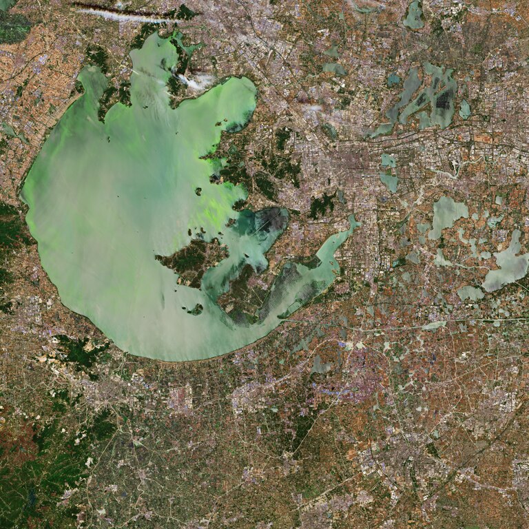
| Description |
English: The Copernicus Sentinel-2 mission takes us over the Lake Tai, the third largest freshwater lake in China. The lake, also known as Lake Taihu, is located in the Jiangsu province and is approximately 70 km long and 60 km wide, with an average water depth of approximately 2 metres. The lake discharges its waters through Wusong, Liu, Huangpu and several other rivers. The Tai Basin is a very developed region in China, and includes the megacities Suzhou, visible east of the lake, Wuxi, visible north of the lake, and the nearby Shanghai. Over the past decades, rapid urbanisation, population growth and excessive fish farming have resulted in eutrophication – where the lake becomes enriched with minerals and nutrients. The increase of nutrients deteriorate the water quality of the lake causing toxic algae blooms to form on the lake’s surface – threatening the quality for millions of people who depend on the lake as a source of drinking water. In 2007, the algal blooms were so severe that the outbreak was declared a health emergency. Water supplies to Wuxi were suspended, leaving two million residents without drinking water for several weeks. In this image captured on 24 May 2019, the algae-infested waters are clearly visible. Algae blooms have been reported in the lake since the 1980s. Many attempts have been made to salvage the water quality of the lake including removal of the algae, closing chemical and manufacturing plants near Tai and stricter water treatment regulations. However, the lake remains to be highly polluted. Agriculture, sewage and manufacturing still affect the lake’s waters – overloading it with nutrients. Sentinel-2 is a two-satellite mission to supply the coverage and data delivery needed for Europe’s Copernicus programme. The mission’s frequent revisits over the same area and high spatial resolution allow changes in inland water bodies to be closely monitored. This image is also featured on the Earth from Space video programme. |
| Date | 15 November 2019 (upload date) |
| Source | Lake Tai, China |
| Author | European Space Agency |
| Other versions |
|
| Activity | Observing the Earth |
| Mission | Sentinel-2 |
| Set | Earth observation image of the week |
| System | Copernicus |

Licensing
[edit]
|
This image contains data from a satellite in the Copernicus Programme, such as Sentinel-1, Sentinel-2 or Sentinel-3. Attribution is required when using this image.
Attribution: Contains modified Copernicus Sentinel data 2019
The use of Copernicus Sentinel Data is regulated under EU law (Commission Delegated Regulation (EU) No 1159/2013 and Regulation (EU) No 377/2014). Relevant excerpts:
Free access shall be given to GMES dedicated data [...] made available through GMES dissemination platforms [...].
Access to GMES dedicated data [...] shall be given for the purpose of the following use in so far as it is lawful:
GMES dedicated data [...] may be used worldwide without limitations in time.
GMES dedicated data and GMES service information are provided to users without any express or implied warranty, including as regards quality and suitability for any purpose. |
This media was created by the European Space Agency (ESA).
Where expressly so stated, images or videos are covered by the Creative Commons Attribution-ShareAlike 3.0 IGO (CC BY-SA 3.0 IGO) licence, ESA being an Intergovernmental Organisation (IGO), as defined by the CC BY-SA 3.0 IGO licence. The user is allowed under the terms and conditions of the CC BY-SA 3.0 IGO license to Reproduce, Distribute and Publicly Perform the ESA images and videos released under CC BY-SA 3.0 IGO licence and the Adaptations thereof, without further explicit permission being necessary, for as long as the user complies with the conditions and restrictions set forth in the CC BY-SA 3.0 IGO licence, these including that:
See the ESA Creative Commons copyright notice for complete information, and this article for additional details.
|
 | |
This file is licensed under the Creative Commons Attribution-ShareAlike 3.0 IGO license. Attribution: ESA, CC BY-SA IGO 3.0
| ||
File history
Click on a date/time to view the file as it appeared at that time.
| Date/Time | Thumbnail | Dimensions | User | Comment | |
|---|---|---|---|---|---|
| current | 13:01, 7 June 2020 |  | 10,980 × 10,980 (344.95 MB) | OptimusPrimeBot (talk | contribs) | #Spacemedia - Upload of https://esamultimedia.esa.int/img/2019/11/Suzhou_Sentinel-2B_MSIL2A_24May2019_432_MM.tif via Commons:Spacemedia |
You cannot overwrite this file.
File usage on Commons
The following page uses this file: