File:La Grande Riviere carte 2.png
From Wikimedia Commons, the free media repository
Jump to navigation
Jump to search
La_Grande_Riviere_carte_2.png (522 × 390 pixels, file size: 43 KB, MIME type: image/png)
File information
Structured data
Captions
Captions
Add a one-line explanation of what this file represents
| DescriptionLa Grande Riviere carte 2.png |
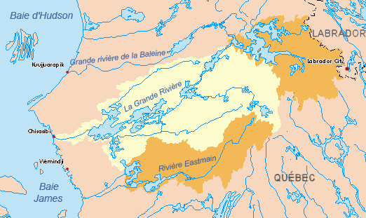
Français : Le bassin versant de La Grande Rivière. En orange, les deux grandes dérivations réalisées dans le cadre du projet de la Baie James. Au nord-est, les travaux de dérivation de la rivière Caniapiscau; au sud, la dérivation EOL (Eastmain, Opinaca, La Grande), qui alimente directement le réservoir Robert-Bourassa. Mis à jour pour 2010.
English: The La Grande River basin. In orange, the two main river diversions engineered as part of the James Bay Project. Northeast, the Caniapiscau River; south, the EOL (Eastmain, Opinaca, La Grande), feeds the Robert-Bourassa reservoir. Updated as of 2010. |
| Date | (UTC) |
| Source | |
| Author |
|
| Other versions |
 (pre-2010). (pre-2010). |
| This is a retouched picture, which means that it has been digitally altered from its original version. The original can be viewed here: La Grande map 2.png:
|
I, the copyright holder of this work, hereby publish it under the following license:
| Public domainPublic domainfalsefalse |
| I, the copyright holder of this work, release this work into the public domain. This applies worldwide. In some countries this may not be legally possible; if so: I grant anyone the right to use this work for any purpose, without any conditions, unless such conditions are required by law. |
Original upload log
[edit]This image is a derivative work of the following images:
- File:La_Grande_map_2.png licensed with PD-self
- 2010-06-10T01:55:14Z P199 522x390 (37514 Bytes) {{Information |Description={{en|1=Drainage basin of the La Grande River, Quebec, Canada. Updated for 2010. For prior to 2010, see '''[[:File:La_Grande_map.png]]'''.*Yellow = original basin*Orange = diverted basins into the La
Uploaded with derivativeFX
File history
Click on a date/time to view the file as it appeared at that time.
| Date/Time | Thumbnail | Dimensions | User | Comment | |
|---|---|---|---|---|---|
| current | 22:55, 28 July 2010 |  | 522 × 390 (43 KB) | Piotron (talk | contribs) | {{Information |Description={{fr|1=Bassin versant de la Grande Rivière (Québec, Canada). Mis à jour pour 2010. Voyez '''File:La_Grande_Riviere_carte.png''' pour la version avant de 2010. *Jaune = bassin original *Orange = bassins détournés vers |
You cannot overwrite this file.
File usage on Commons
The following page uses this file:
File usage on other wikis
The following other wikis use this file:
- Usage on arz.wikipedia.org
- Usage on bg.wikipedia.org
- Usage on es.wikipedia.org
- Usage on fr.wikipedia.org
- Usage on hy.wikipedia.org
- Usage on it.wikipedia.org
- Usage on nl.wikipedia.org
- Usage on uk.wikipedia.org
- Usage on www.wikidata.org
