File:Kineski most sat.jpg
Jump to navigation
Jump to search

Size of this preview: 800 × 561 pixels. Other resolutions: 320 × 224 pixels | 640 × 449 pixels | 1,024 × 718 pixels | 1,273 × 893 pixels.
Original file (1,273 × 893 pixels, file size: 289 KB, MIME type: image/jpeg)
Captions
Captions
Add a one-line explanation of what this file represents
Summary
[edit]
| Description |
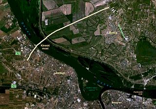
Српски / srpski: Satelitski snimak položaja budućeg Kineskog mosta u Beogradu. Žutim su označene saobraćajnice koje će biti izgrađene.
English: Satellite image of the position of future Chinese Bridge in Belgrade. |
| Date | |
| Source | Nasa World Wind |
| Author | Matija |
Napomena: Mislim da mapica nije tacna, jer se most nalazi istocnije, bar sto se zemunske strane tice. Jasno se vidi gde je iskljucenje sa autoputa Beograd-Zagreb kod zmaja ka Novom Sadu. Pristup mostu bi trebalo da se vezuje na taj pravac kod one krivine od 90 stepeni, zar ne?
Licensing
[edit]
| This image is in the public domain because it is a screenshot from NASA’s globe software World Wind using a public domain layer, such as Blue Marble, MODIS, Landsat, SRTM, USGS or GLOBE.
|
 |
File history
Click on a date/time to view the file as it appeared at that time.
| Date/Time | Thumbnail | Dimensions | User | Comment | |
|---|---|---|---|---|---|
| current | 15:15, 19 January 2010 | | 1,273 × 893 (289 KB) | Matija (talk | contribs) | {{Information |Description={{sr|1=Satelitski snimak položaja budućeg Kineskog mosta u Beogradu. Žutim su označene saobraćajnice koje će biti izgrađene.}} {{en|1=Satellite image of the position of future Chinese Bridge in Belgra |
You cannot overwrite this file.
File usage on Commons
The following 2 pages use this file:
File usage on other wikis
The following other wikis use this file:
- Usage on cs.wikipedia.org
- Usage on en.wikipedia.org
- Usage on fr.wikipedia.org
- Usage on hr.wikipedia.org
- Usage on mk.wikipedia.org
- Usage on sh.wikipedia.org
- Usage on sr.wikipedia.org
- Usage on th.wikipedia.org
- Usage on www.wikidata.org