File:Karte zum Projekt Johann Jacob Hills zur Melioration des Gebietes zwischen Neckar, Rhein, Main und Odenwald durch Regulierung des Gewässersystems bei gleichzeitiger Schaffung schiffbarer Verbindungen.jpg
Jump to navigation
Jump to search

Size of this preview: 800 × 324 pixels. Other resolutions: 320 × 130 pixels | 640 × 259 pixels | 1,024 × 415 pixels | 1,280 × 518 pixels | 4,634 × 1,876 pixels.
Original file (4,634 × 1,876 pixels, file size: 11.66 MB, MIME type: image/jpeg)
Captions
Captions
Add a one-line explanation of what this file represents
Summary
[edit]
| Description |
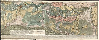
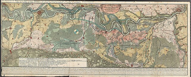
Deutsch: Karte zum Projekt Johann Jacob Hills zur Melioration des Gebietes zwischen Neckar, Rhein, Main und Odenwald durch Regulierung des Gewässersystems bei gleichzeitiger Schaffung schiffbarer Verbindungen, 1779 (Hessisches Staatsarchiv Darmstadt P 1 Nr. 2147) Zum Archivale: https://arcinsys.hessen.de/arcinsys/detailAction?detailid=v2837735 |
| Date | |
| Source | Own work |
| Author | Hessisches Landesarchiv |
Licensing
[edit]
I, the copyright holder of this work, hereby publish it under the following license:
This file is licensed under the Creative Commons Attribution-Share Alike 4.0 International license.
- You are free:
- to share – to copy, distribute and transmit the work
- to remix – to adapt the work
- Under the following conditions:
- attribution – You must give appropriate credit, provide a link to the license, and indicate if changes were made. You may do so in any reasonable manner, but not in any way that suggests the licensor endorses you or your use.
- share alike – If you remix, transform, or build upon the material, you must distribute your contributions under the same or compatible license as the original.
File history
Click on a date/time to view the file as it appeared at that time.
| Date/Time | Thumbnail | Dimensions | User | Comment | |
|---|---|---|---|---|---|
| current | 09:48, 7 April 2020 | 4,634 × 1,876 (11.66 MB) | Hessisches Landesarchiv (talk | contribs) | Uploaded own work with UploadWizard |
You cannot overwrite this file.
File usage on Commons
There are no pages that use this file.