File:Karte der Steiermark als Brustschild des Doppeladlers.jpg
Jump to navigation
Jump to search

Size of this preview: 543 × 599 pixels. Other resolutions: 218 × 240 pixels | 435 × 480 pixels | 696 × 768 pixels | 928 × 1,024 pixels | 1,856 × 2,048 pixels | 4,710 × 5,196 pixels.
Original file (4,710 × 5,196 pixels, file size: 24.33 MB, MIME type: image/jpeg)
Captions
Captions
Add a one-line explanation of what this file represents
Summary
[edit]
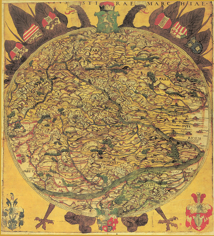
| Description | historische Landkarte, 1561: Ducatus Styriae Marchiae. Kreisrunde Karte der Steiermark als Brustschild des Doppeladlers. Älteste und erste ausführliche Karte der Steiermark. Maßstab etwa 1:470.000. Aus: Typi chorographici provinciarum Austriae, Wien 1561. Die Südgrenze an der Save fehlt - das Gebiet um Cilli war erst um 1456 an die Habsburger gefallen und noch nicht vollständig als Teil der Steiermark gesehen. Die vielen Verzerrungen und Unrichtigkeiten sind einerseits auf das für das Gebiet der Steiermark unpassende Kreisformat, andererseits auf den Wissensstand der Kartographie der Zeit zurückzuführen. Dennoch blieb die Karte bis in das 18. Jahrhundert, jedenfalls bis zu thumb|G.M.Vischer: Karte ("Fertilissima") Georg Matthäus Vischer 1678 Vorbild für andere Werke. Quelle: Karl Spreitzhofer: Wolfgang Lazius: Karte der Steiermark "Ducatus Stiriae Marchiae". In: Helfried Valentinisch (Hrsg.): Steiermark Edition. Teil Grenzmark - Herzogtum - Burgenland, Blatt STE01011. Archiv Verlag Wien 1990 ff. |
| Date | 1545/1561 |
| Source | Österreichische Nationalbibliothek, Kartensammlung 393.221-E.K. Die Karte war 1545 fertiggestellt, erschien als Einzelblatt in Nürnberg und 1561 als Teil des Sammelwerkes. |
| Author | Wolfgang Lazius, 1514-1565 |
| Permission (Reusing this file) |
historische Landkarte des 16. Jahrhunderts, freies Werk |
Licensing
[edit]
|
This work is in the public domain in its country of origin and other countries and areas where the copyright term is the author's life plus 70 years or fewer. | |
| This file has been identified as being free of known restrictions under copyright law, including all related and neighboring rights. | |
File history
Click on a date/time to view the file as it appeared at that time.
| Date/Time | Thumbnail | Dimensions | User | Comment | |
|---|---|---|---|---|---|
| current | 19:27, 1 July 2010 | | 4,710 × 5,196 (24.33 MB) | Josef Moser (talk | contribs) | {{Information |Description=historische Landkarte, 17. Jahrhundert: Ducatus Styriae Marchiae. Kreisrunde Karte der Steiermark als Brustschild des Doppeladlers. |Source=steiermärkisches Landesarchiv |Date=17. Jahrhundert |Author=unbekannt, jedenfalls seit |
You cannot overwrite this file.
File usage on Commons
There are no pages that use this file.
File usage on other wikis
The following other wikis use this file:
- Usage on de.wikipedia.org
Metadata
Categories:
- Maps by Wolfgang Lazius
- Maps of the Duchy of Styria
- Innerösterreich
- Maps of Graz
- Maps of Bezirk Deutschlandsberg
- Bezirk Leibnitz
- Bezirk Voitsberg
- Bezirk Weiz
- Bezirk Graz-Umgebung
- Bezirk Hartberg-Fürstenfeld
- Bezirk Bruck-Mürzzuschlag
- Bezirk Leoben
- Old maps of Styria
- Bezirk Liezen
- Bezirk Murau
- Bezirk Südoststeiermark
- Bezirk Murtal
- Coats of arms on maps
- Figurative maps
- Circular maps
- Maps of Austria in art