File:Karte Nordostgrönlands 2. Dt. Nordpolarexpedition.jpg
Jump to navigation
Jump to search

Size of this preview: 369 × 599 pixels. Other resolutions: 148 × 240 pixels | 296 × 480 pixels | 649 × 1,053 pixels.
Original file (649 × 1,053 pixels, file size: 721 KB, MIME type: image/jpeg)
Captions
Captions
Add a one-line explanation of what this file represents
Summary
[edit]
| Description |
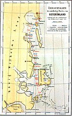
Deutsch: Karte der in Nordostgrönland von der 2. Deutschen Nordpolarexpedition entdeckten Gebiete |
| Date | |
| Source | Die zweite deutsche Nordpolarfahrt in den Jahren 1869 und 1870 unter Führung des Kapitän Karl Koldewey |
| Author | Unknown author |
Licensing
[edit]
|
This work is in the public domain in its country of origin and other countries and areas where the copyright term is the author's life plus 70 years or fewer. | |
| This file has been identified as being free of known restrictions under copyright law, including all related and neighboring rights. | |
File history
Click on a date/time to view the file as it appeared at that time.
| Date/Time | Thumbnail | Dimensions | User | Comment | |
|---|---|---|---|---|---|
| current | 16:46, 23 May 2019 | | 649 × 1,053 (721 KB) | Dreizung (talk | contribs) | {{Information |description ={{de|1=Karte der in Nordostgrönland von der 2. Deutschen Nordpolarexpedition entdeckten Gebiete }} |date =1874 |source =Die zweite deutsche Nordpolarfahrt in den Jahren 1869 und 1870 unter Führung des Kapitän Karl Koldewey |author =unknown }} Category:Second German North Polar Expedition |
You cannot overwrite this file.
File usage on Commons
There are no pages that use this file.