File:Kaiser Crater Dunes (PIA25802).tiff

Original file (591 × 2,729 pixels, file size: 703 KB, MIME type: image/tiff)
Captions
Captions
Summary
[edit]| Description |
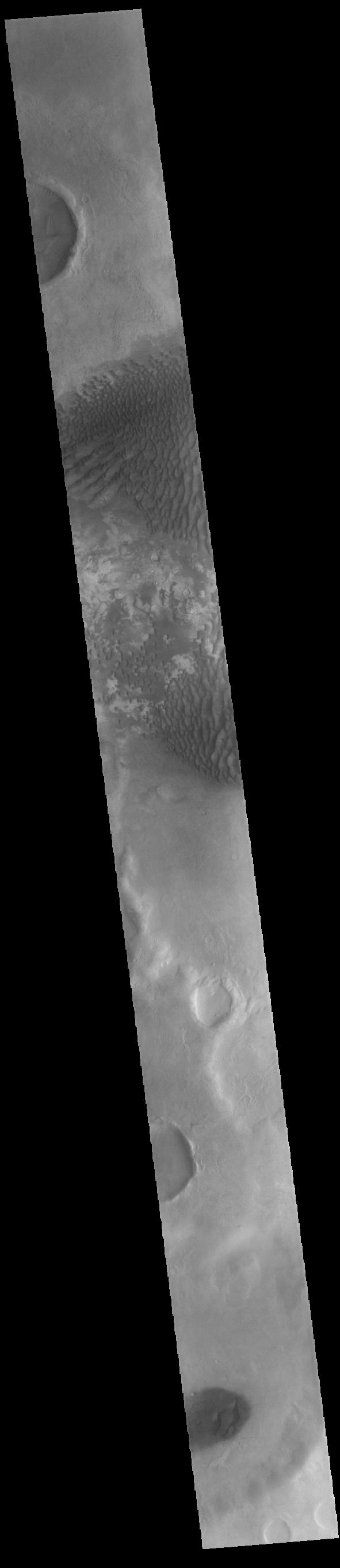
English: .png) Context image This VIS image is located in Kaiser Crater and shows several regions of sand dunes located on the southern part of the crater floor. The crater floor is visible between the dunes, indicating that there is a limited sand supply creating the dunes. These dunes are composed of basaltic sand that has collected in the bottom of the crater. The topographic depression of the crater forms a sand trap that prevents the sand from escaping. Dune fields are common in the bottoms of craters on Mars and appear as dark splotches that often lean up against the downwind walls of the craters. Dunes are useful for studying both the geology and meteorology of Mars. The sand forms by erosion of larger rocks, but it is unclear when and where this erosion took place on Mars or how such large volumes of sand could be formed. Local winds continue to move the sand dunes across the crater floor. There are two sides to a dune, the low angle slope of the windward face and the high angle slope of the leeward side. The steep side is called the slip face. Wind blows sand grains up the low angle slope of the dunes which then "fall down" the slip face. In this way the whole dune moves towards the slip face. The winds blow from the windward to the leeward side of the dunes. In this image the slip faces are on the left side of the dune, so the dunes are slowly moving to the left side of this image. Kaiser Crater is 207km in diameter (129 miles) and is located in Noachis Terra west of Hellas Planitia. Orbit Number: 92902 Latitude: -47.3127 Longitude: 19.2697 Instrument: VIS Captured: 2022-11-23 20:18 Please see the THEMIS Data Citation Note for details on crediting THEMIS images. NASA's Jet Propulsion Laboratory manages the 2001 Mars Odyssey mission for NASA's Science Mission Directorate, Washington, D.C. The Thermal Emission Imaging System (THEMIS) was developed by Arizona State University, Tempe, in collaboration with Raytheon Santa Barbara Remote Sensing. The THEMIS investigation is led by Dr. Philip Christensen at Arizona State University. Lockheed Martin Astronautics, Denver, is the prime contractor for the Odyssey project, and developed and built the orbiter. Mission operations are conducted jointly from Lockheed Martin and from JPL, a division of the California Institute of Technology in Pasadena. |
| Date | (published) |
| Source | Catalog page · Full-res (JPEG · TIFF) · Full-res ([ MP4]) · Full-res ([ GIF]) |
| Author | NASA/JPL-Caltech/ASU |
| Other versions |
|
This image or video was catalogued by Jet Propulsion Laboratory of the United States National Aeronautics and Space Administration (NASA) under Photo ID: PIA25802. This tag does not indicate the copyright status of the attached work. A normal copyright tag is still required. See Commons:Licensing. Other languages:
|
| This media is a product of the 2001 Mars Odyssey mission Credit and attribution belongs to the Thermal Emission Imaging System (THEMIS) team, NASA/JPL-Caltech/ASU |
Licensing
[edit]
|
The copyright holder of this file, NASA/JPL-Caltech, allows anyone to use it for any purpose, provided that the copyright holder is properly attributed. Redistribution, derivative work, commercial use, and all other use is permitted. |
|
|
| According to JPL's image use policy additional restriction is that no endorsement of any product or service by Caltech, JPL or NASA is claimed or implied.
Caltech's disclaimer: Caltech makes no representations or warranties with respect to ownership of copyrights in the images, and does not represent others who may claim to be authors or owners of copyright of any of the images, and makes no warranties as to the quality of the images. Caltech shall not be responsible for any loss or expenses resulting from the use of the images, and you release and hold Caltech harmless from all liability arising from such use. Usage on the English Wikipedia: On the English Wikipedia you can use the {{JPL Image}} template to display the copyright notice. (See w:Wikipedia:Using JPL images for details) |
File history
Click on a date/time to view the file as it appeared at that time.
| Date/Time | Thumbnail | Dimensions | User | Comment | |
|---|---|---|---|---|---|
| current | 13:45, 8 August 2023 | 591 × 2,729 (703 KB) | OptimusPrimeBot (talk | contribs) | #Spacemedia - Upload of https://photojournal.jpl.nasa.gov/tiff/PIA25802.tif via Commons:Spacemedia |
You cannot overwrite this file.
File usage on Commons
The following 2 pages use this file:
.jpg)