File:Kadasterkaart Maastricht 1823-1830, sectie A, blad 11, Wyck - Wycker Grachtstraat (detail).jpg
Jump to navigation
Jump to search
Size of this preview: 800 × 311 pixels. Other resolutions: 320 × 125 pixels | 640 × 249 pixels | 1,024 × 398 pixels | 1,280 × 498 pixels | 2,560 × 996 pixels | 5,700 × 2,218 pixels.
Original file (5,700 × 2,218 pixels, file size: 2.92 MB, MIME type: image/jpeg)
Captions
Captions
Add a one-line explanation of what this file represents
Summary
[edit]| Description |
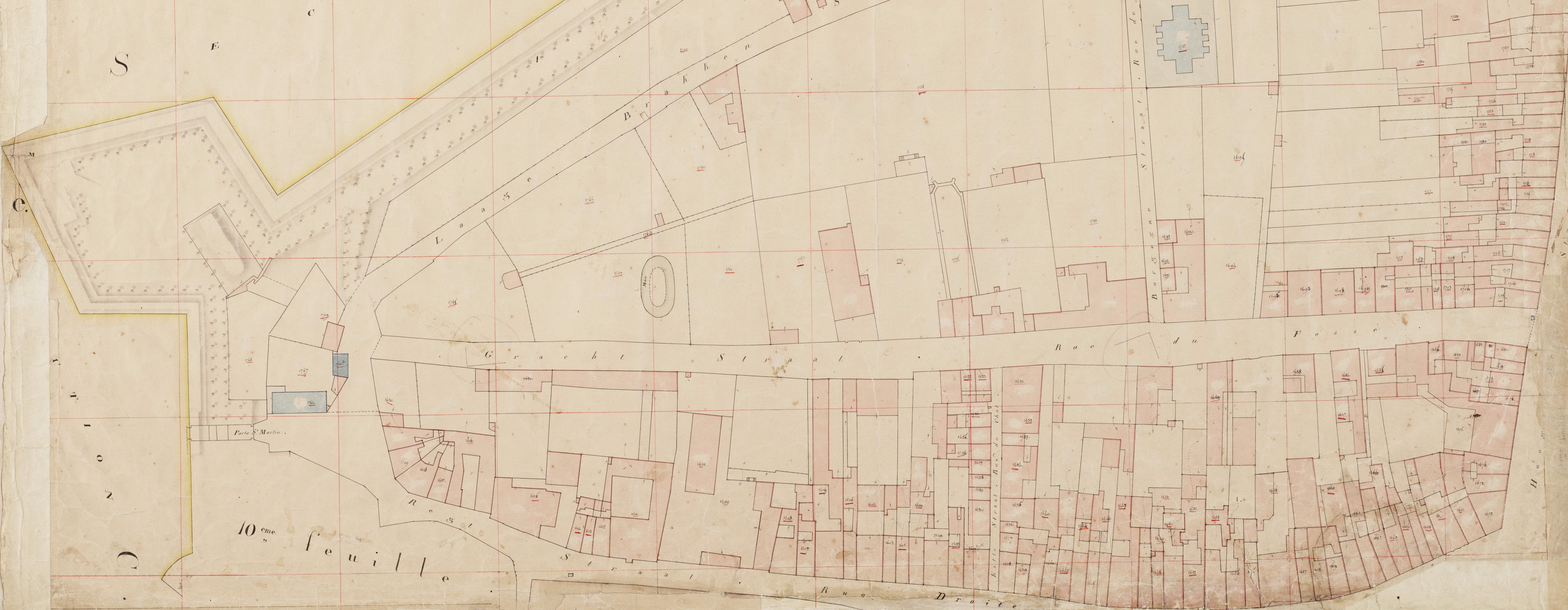
Nederlands: Detail van een kadastrale minuutkaart van Maastricht, sectie A, blad 11, perceelnummers 1597-1780. Op deze kaart is het gebied ten oosten van de Rechtstraat in Wyck weergegeven. In blauw: overheids- en kerkelijke gebouwen, o.a. het kruithuis Bourgogne. Midden: Wycker Grachtstraat. Collectie RHCL Maastricht, Kadaster Limburg, MIN11058A11. |
| Date | between 1823 and 1830 |
| Source | https://beeldbank.rhcl.nl/detail.php?nav_id=14-1&id=5052660&index=11 |
| Author | P.J. Sotiau (Kadaster Limburg) |
| Other versions |

.jpg&action=edit§ion=1)
Licensing
[edit].jpg&action=edit§ion=2)
|
This work is in the public domain in its country of origin and other countries and areas where the copyright term is the author's life plus 100 years or fewer. This work is in the public domain in the United States because it was published (or registered with the U.S. Copyright Office) before January 1, 1929. | |
| This file has been identified as being free of known restrictions under copyright law, including all related and neighboring rights. | |
File history
Click on a date/time to view the file as it appeared at that time.
| Date/Time | Thumbnail | Dimensions | User | Comment | |
|---|---|---|---|---|---|
| current | 15:14, 23 March 2021 | 5,700 × 2,218 (2.92 MB) | Kleon3 (talk | contribs) | File:Kadasterkaart Maastricht 1823-1830, sectie A, blad 11, Wyck - Rechtstraat-oost.jpg cropped 5 % horizontally, 42 % vertically using CropTool with precise mode. |
You cannot overwrite this file.
File usage on Commons
The following page uses this file:
File usage on other wikis
The following other wikis use this file:
- Usage on nl.wikipedia.org
.jpg&oldid=546878253)