File:KAARTEN SGD - Begrenzing landinrichtingsgebied en te onteigenen gebied Midden Delfland.jpeg
Jump to navigation
Jump to search

Size of this preview: 672 × 600 pixels. Other resolutions: 269 × 240 pixels | 538 × 480 pixels | 860 × 768 pixels | 1,147 × 1,024 pixels | 1,902 × 1,698 pixels.
Original file (1,902 × 1,698 pixels, file size: 541 KB, MIME type: image/jpeg)
Captions
Captions
Add a one-line explanation of what this file represents
Summary
[edit]| Title |
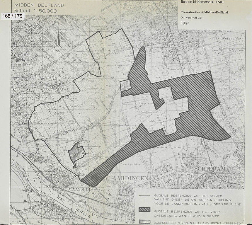
KAARTEN SGD - Begrenzing landinrichtingsgebied en te onteigenen gebied Midden Delfland |
||||||||||||||||||||||||||
| Description |
Bijlage van de Memorie van Toelichting betreffende Regelen met betrekking tot de reconstructie van Midden-Delfland, Rapport van de commissie bezwaarschriften Midden-Delfland |
||||||||||||||||||||||||||
| Date | |||||||||||||||||||||||||||
| Source |
This image in context: http://www.statengeneraaldigitaal.nl/document?id=sgd:mpeg21:19711972:0005186&pagina=10;
|
||||||||||||||||||||||||||
| Creator |
English: The individual creators of this map are unknown, it was commissioned by the House of Representatives of the Netherlands.
Nederlands: De precieze makers van deze kaart zijn niet bekend, hij werd in opdracht van de Tweede Kamer der Staten-Generaal gemaakt. |
||||||||||||||||||||||||||
| Permission (Reusing this file) |
|
||||||||||||||||||||||||||
| Geotemporal data | |||||||||||||||||||||||||||
| Date depicted | |||||||||||||||||||||||||||
| Map location | Delfland | ||||||||||||||||||||||||||
| Scale | 1:50.000 | ||||||||||||||||||||||||||
| Bounding box |
|
||||||||||||||||||||||||||
| Georeferencing | If inappropriate please set warp_status = skip to hide. | ||||||||||||||||||||||||||
| Bibliographic data | |||||||||||||||||||||||||||
| Publisher |
This map was commissioned and published by the
|
||||||||||||||||||||||||||
| Archival data | |||||||||||||||||||||||||||
| Collection |
This map was digitized by the
|
||||||||||||||||||||||||||
| Notes |
Nederlands: landinrichting, ruilverkaveling, grond-onteigening |
||||||||||||||||||||||||||


File history
Click on a date/time to view the file as it appeared at that time.
| Date/Time | Thumbnail | Dimensions | User | Comment | |
|---|---|---|---|---|---|
| current | 23:39, 15 November 2015 | | 1,902 × 1,698 (541 KB) | OlafJanssen (talk | contribs) | GWToolset: Creating mediafile for OlafJanssen. |
You cannot overwrite this file.
File usage on Commons
There are no pages that use this file.