File:Jewish National Fund, Karte von Erez Israel (FL197694341 1108520).jpg
Jump to navigation
Jump to search

Size of this preview: 428 × 600 pixels. Other resolutions: 171 × 240 pixels | 343 × 480 pixels | 548 × 768 pixels | 731 × 1,024 pixels | 1,462 × 2,048 pixels | 11,896 × 16,663 pixels.
Original file (11,896 × 16,663 pixels, file size: 263.59 MB, MIME type: image/jpeg)
Captions
Captions
Add a one-line explanation of what this file represents
Summary
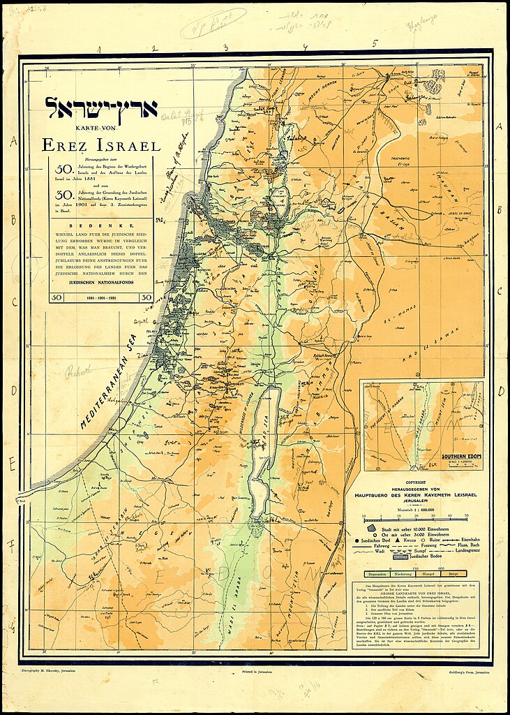
[edit]| Jewish National Fund: Karte von Erez Israel
( |
||||||||||||||||||||||||
|---|---|---|---|---|---|---|---|---|---|---|---|---|---|---|---|---|---|---|---|---|---|---|---|---|
| Artist |
|
|||||||||||||||||||||||
| Title |
Karte von Erez Israel |
|||||||||||||||||||||||
| Publisher |
Goldberg's press Tel Aviv |
|||||||||||||||||||||||
| Description |
Karte von Erez Israel. Herausgegeben von Hauptbuero des Keren Kayemeth LeIsrael. |
|||||||||||||||||||||||
| Language | German | |||||||||||||||||||||||
| Publication date | 1931 | |||||||||||||||||||||||
| Medium | 1 sheet : color ; | |||||||||||||||||||||||
| Dimensions | height: 70 cm (27.5 in); width: 50 cm (19.6 in) | |||||||||||||||||||||||
| Collection |
|
|||||||||||||||||||||||
| Current location |
|
|||||||||||||||||||||||
| Place of publication | Jerusalem | |||||||||||||||||||||||
| search Merhav catalog | Jerusalem | |||||||||||||||||||||||
| Notes | Zincography M. Pikovsky, Jerusalem; See also: Pal 1121, Israel h174, Pal 1120.5 (Editions in English Hebrew, and French).; Inset map: Southern Edom; Includes indication of lands owned by Jews. | |||||||||||||||||||||||
| scale | 1:600,000 cm | |||||||||||||||||||||||
| IE PID | IE197694339 | |||||||||||||||||||||||
| Rosetta filename | FL197694341 | |||||||||||||||||||||||
| NNL item ID (P3959) | 997011085200005171 | |||||||||||||||||||||||
| search Merhav catalog | German, Jewish National Fund | |||||||||||||||||||||||
| search Merhav catalog | Erez Israelארץ ישראלLand tenureEretz IsraelMapsGoldberg's press Tel Aviv | |||||||||||||||||||||||
| Source/Photographer |
|
|||||||||||||||||||||||
| Other versions | ||||||||||||||||||||||||
| Jpg / Tif version |
|
|||||||||||||||||||||||


.jpg)

.jpg&action=edit§ion=1)
Licensing
[edit].jpg&action=edit§ion=2)
This work created by the United Kingdom Government is in the public domain.
This is because it is one of the following:
HMSO has declared that the expiry of Crown Copyrights applies worldwide (ref: HMSO Email Reply)
|
 |
File history
Click on a date/time to view the file as it appeared at that time.
| Date/Time | Thumbnail | Dimensions | User | Comment | |
|---|---|---|---|---|---|
| current | 13:14, 11 August 2023 | | 11,896 × 16,663 (263.59 MB) | Geagea (talk | contribs) | pattypan 22.03 |
You cannot overwrite this file.
File usage on Commons
The following page uses this file:
.jpg&oldid=847430645)