File:Jeannette crew course map-fr.svg
Jump to navigation
Jump to search

Size of this PNG preview of this SVG file: 741 × 599 pixels. Other resolutions: 297 × 240 pixels | 594 × 480 pixels | 950 × 768 pixels | 1,266 × 1,024 pixels | 2,532 × 2,048 pixels | 1,443 × 1,167 pixels.
Original file (SVG file, nominally 1,443 × 1,167 pixels, file size: 853 KB)
Captions
Captions
Add a one-line explanation of what this file represents
Summary
[edit]| Description |
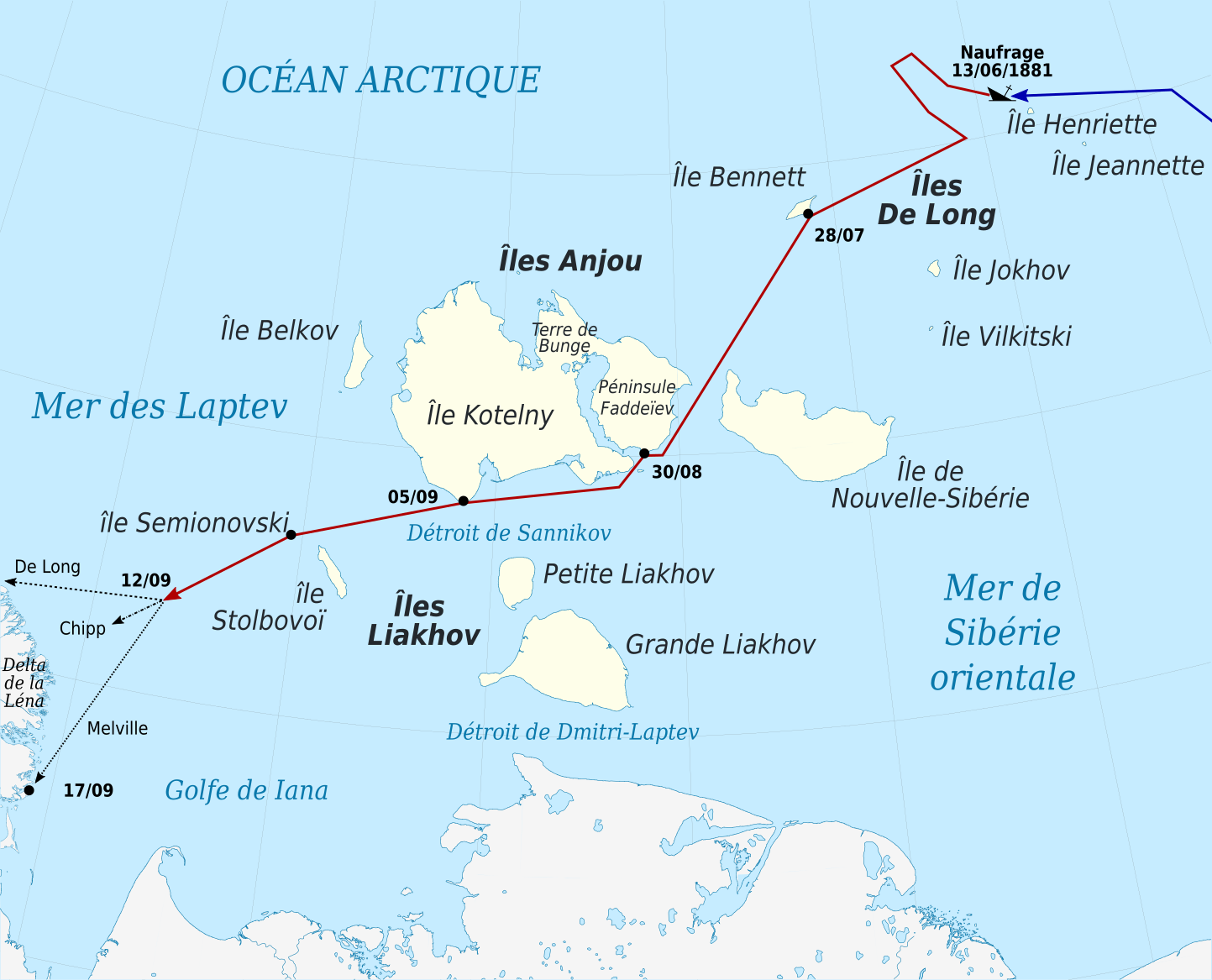
English: Route(s) of the Jeannette party after leaving the ship, which was crushed by Arctic ice near Henrietta Island in 1881. The party remained together until encountering a storm northeast of the Lena Delta, after which boats headed by De Long, Chipp, and Melville went in separate directions toward the Siberian coast.
Français : Carte du trajet suivi par les membres de l'expédition Jeannette après le naufrage de leur navire le 13 juin 1881, près de l'île Henriette. Alors qu'ils approchaient du delta de la Léna, sur le continent, une tempête sépara les trois canots, dirigés par De Long, Chipp, and et Melville, chacun suivant une direction et un sort différent. |
||
| Date | (UTC) | ||
| Source |
|
||
| Author | Sémhur | ||
| Other versions |
| ||
| Attribution (required by the license) | © Sémhur / Wikimedia Commons / | ||
| SVG development |
|

| Object location | | View this and other nearby images on: OpenStreetMap |
|---|
Licensing
[edit]
I, the copyright holder of this work, hereby publish it under the following licenses:
| Copyleft: This work of art is free; you can redistribute it and/or modify it according to terms of the Free Art License. You will find a specimen of this license on the Copyleft Attitude site as well as on other sites. |
This file is licensed under the Creative Commons Attribution-Share Alike Attribution-Share Alike 4.0 International, 3.0 Unported, 2.5 Generic, 2.0 Generic and 1.0 Generic license.
- You are free:
- to share – to copy, distribute and transmit the work
- to remix – to adapt the work
- Under the following conditions:
- attribution – You must give appropriate credit, provide a link to the license, and indicate if changes were made. You may do so in any reasonable manner, but not in any way that suggests the licensor endorses you or your use.
- share alike – If you remix, transform, or build upon the material, you must distribute your contributions under the same or compatible license as the original.
You may select the license of your choice.
File history
Click on a date/time to view the file as it appeared at that time.
| Date/Time | Thumbnail | Dimensions | User | Comment | |
|---|---|---|---|---|---|
| current | 20:26, 18 September 2017 | | 1,443 × 1,167 (853 KB) | Sémhur (talk | contribs) | |
| 20:20, 18 September 2017 |  | 721 × 583 (835 KB) | Sémhur (talk | contribs) | == {{int:filedesc}} == {{Information |Description= {{en|1=Route(s) of the Jeannette party after leaving the ship, which was crushed by Arctic ice near Henrietta Island in 1881. The party remained together until encountering... |
You cannot overwrite this file.
File usage on Commons
The following page uses this file:
File usage on other wikis
The following other wikis use this file:
- Usage on es.wikipedia.org
- Usage on fr.wikipedia.org