File:Jan Blankenbrug in A2 naast oude Lekbrug.jpg
Jump to navigation
Jump to search

Size of this preview: 800 × 533 pixels. Other resolutions: 320 × 213 pixels | 640 × 427 pixels | 1,024 × 683 pixels | 1,280 × 853 pixels | 2,560 × 1,707 pixels | 3,888 × 2,592 pixels.
Original file (3,888 × 2,592 pixels, file size: 1.3 MB, MIME type: image/jpeg)
Captions
Captions
Add a one-line explanation of what this file represents
Summary
[edit]
| Description |
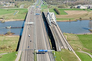
Nederlands: Links de Jan Blankenbrug over de Lek, in de A2 tussen Vianen en Nieuwegein; rechts de oude Lekbrug. |
|||
| Date | ||||
| Source | https://beeldbank.rws.nl, Rijkswaterstaat | |||
| Author | Joop van Houdt | |||
| Permission (Reusing this file) |
https://beeldbank.rws.nl, Rijkswaterstaat must be mentioned as the source. Original text: Nederlands: "De (intellectuele) eigendomsrechten van het beeldmateriaal liggen bij de Rijkswaterstaat, Data-ICT-Dienst, Beeldarchief Rijkswaterstaat. Er gelden geen extra kosten voor auteursrechten maar wel is bij iedere publicatie bronvermelding verplicht: https://beeldbank.rws.nl, Rijkswaterstaat".
English: "The (intellectual) ownership of the image material lies with the Rijkswaterstaat, Data-ICT-Dienst, Beeldarchief Rijkswaterstaat. No extra costs are associated with copyright, although it is mandatory to acknowledge the source with each publication: https://beeldbank.rws.nl, Rijkswaterstaat".
The original location of the image was here |
| Camera location | | View this and other nearby images on: OpenStreetMap |
|---|
Licensing
[edit]

|
The copyright holder of this file allows anyone to use it for any purpose, provided that the copyright holder is properly attributed. Redistribution, derivative work, commercial use, and all other use is permitted. |
|
|
File history
Click on a date/time to view the file as it appeared at that time.
| Date/Time | Thumbnail | Dimensions | User | Comment | |
|---|---|---|---|---|---|
| current | 14:34, 27 January 2011 | | 3,888 × 2,592 (1.3 MB) | Fietsbel (talk | contribs) | {{Information |Description ={{nl|1=Links de Jan Blankenbrug over de Lek, in de A2 tussen Vianen en Nieuwegein; rechts de oude Lekbrug.}} |Source =https://beeldbank.rws.nl, Rijkswaterstaat |Author =Joop van Houdt |Date =2010-04 |
You cannot overwrite this file.
File usage on Commons
The following 2 pages use this file:
File usage on other wikis
The following other wikis use this file:
- Usage on ca.wikipedia.org
- Usage on cs.wikipedia.org
- Usage on de.wikipedia.org
- Usage on en.wikipedia.org
- Usage on fr.wikipedia.org
- Usage on nl.wikipedia.org
- Usage on www.wikidata.org