Category:Lekbrug
Jump to navigation
Jump to search
| Camera location | | View all coordinates using: OpenStreetMap |
|---|
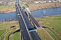
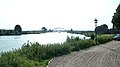
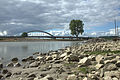
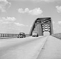
Nederlands: Afbeeldingen van de voormalige Lekbrug, een boogbrug over de rivier de Lek en was vroeger een onderdeel van de A2. Sinds de opening van de Jan Blankenbrug wordt de Lekbrug niet meer gebruikt. De Lekbrug is op 21 november 2021 verwijderd
English: Pictures of the former Lekbrug, an arch bridge spanning about the river the river Lek and used to be a part of the A2. Since the Jan Blankenbrug opened for traffic, the Lekbrug is not used anymore. The Lekbrug is removed on November 21, 2021
bridge in Netherlands  | |||||
| Upload media | |||||
| Instance of | |||||
|---|---|---|---|---|---|
| Location |
| ||||
| Crosses | |||||
| Carries | |||||
| Inception |
| ||||
 | |||||
Media in category "Lekbrug"
The following 34 files are in this category, out of 34 total.
-
 A2 - Jan Blankenbrug, Lekbrug - RWS 421287.jpg 3,888 × 2,592; 3.25 MB
-
 A2 - Jan Blankenbrug, Lekbrug - RWS 421290.jpg 3,888 × 2,592; 3.1 MB
-
 Aanlegsteiger in de nevengeul van de rivier de Lek bij Vianen.jpg 4,770 × 3,177; 3.86 MB
-

-
 Auto op een brug bij Utrecht, Bestanddeelnr 252-0134.jpg 2,595 × 2,584; 781 KB
-
 Boogbrug Vianen vanaf de dijk.jpg 1,536 × 2,048; 704 KB
-
 Boogbrug Vianen.jpg 1,536 × 2,048; 663 KB
-
 De A2 Lekbrug vanuit Vreeswijk - panoramio.jpg 3,296 × 1,854; 692 KB
-
 De getijde werking is bij Vianen goed zichtbaar, hier zien we de Lek bij eb.jpg 4,770 × 3,177; 4.74 MB
-
 De Lek bij Vianen UT.jpg 4,770 × 3,177; 4.74 MB
-
 De Lek IJsselstein 01.JPG 4,288 × 2,848; 2.91 MB
-
 De markante Lekbrug bij Vianen.jpg 4,770 × 3,177; 4.46 MB
-
 De Oude Lekbrug bij Vianen UT.jpg 4,770 × 3,177; 4.56 MB
-
 Jan Blankenbrug in A2 naast oude Lekbrug.jpg 3,888 × 2,592; 1.3 MB
-
 Lekbrug & Jan Blankenbrug - Rijksweg A2 - Vianen - NL (51163724923).jpg 7,087 × 4,724; 26.07 MB
-
 Lekbrug bij Vianen.jpg 1,009 × 673; 100 KB
-
 Lekbrug en Jan Blankenbrug Vianen 2.jpg 4,928 × 3,264; 6.21 MB
-
 Lekbrug en Jan Blankenbrug Vianen.jpg 4,928 × 3,264; 7.5 MB
-
 Lekbrug Vianen 1952.jpg 1,024 × 1,000; 206 KB
-
 Lekbrug.Vianen.jpg 2,657 × 1,992; 1.24 MB
-
 NIMH - 2011 - 5282 - Aerial photograph of Vianen, The Netherlands.jpg 4,000 × 2,793; 2.2 MB
-
 NIMH - 2011 - 5283 - Aerial photograph of Vianen, The Netherlands.jpg 4,000 × 2,716; 1.58 MB
-
 NIMH - 2011 - 5284 - Aerial photograph of Vianen, The Netherlands.jpg 4,000 × 2,359; 1.56 MB
-
 NIMH - 2011 - 9059 - Aerial photograph of Vianen, The Netherlands.jpg 4,000 × 2,900; 2.26 MB
-
 NIMH - 2011 - 9060 - Aerial photograph of Vianen, The Netherlands.jpg 4,000 × 2,717; 2.98 MB
-
 Olympias 10e tour door Nederland. Passeren Lekbrug, Bestanddeelnr 912-5823.jpg 3,712 × 2,452; 1.62 MB
-
 Peace Bridge Vianen Netherlands 2015.jpg 511 × 273; 55 KB
-
 Pontwaard met nevengeul. in Vianen.jpg 4,770 × 3,177; 4.35 MB
-

-
 Verkeersbrug (Lekbrug) te Vreeswijk-Vianen met de hulpstellingen, Bestanddeelnr 256-2212.jpg 4,150 × 5,864; 2.14 MB
-

-
 VianenBrug01.JPG 4,608 × 3,072; 4.41 MB
-
 VianenBrug02.JPG 4,608 × 3,072; 5.02 MB
-


,_Bestanddeelnr_252-0141.jpg)


_te_Vreeswijk-Vianen_met_de_hulpstellingen_en_hulpbruggen,_Bestanddeelnr_256-2214.jpg)
_te_Vreeswijk-Vianen_met_de_hulpstellingen,_Bestanddeelnr_256-2212.jpg)


.jpg)