File:Iron Protector on Bridge No 130, Grand Union Canal - geograph.org.uk - 1462979.jpg
Jump to navigation
Jump to search
Size of this preview: 450 × 600 pixels. Other resolutions: 180 × 240 pixels | 480 × 640 pixels.
Original file (480 × 640 pixels, file size: 83 KB, MIME type: image/jpeg)
Captions
Captions
Add a one-line explanation of what this file represents
Summary
[edit]
| Description |
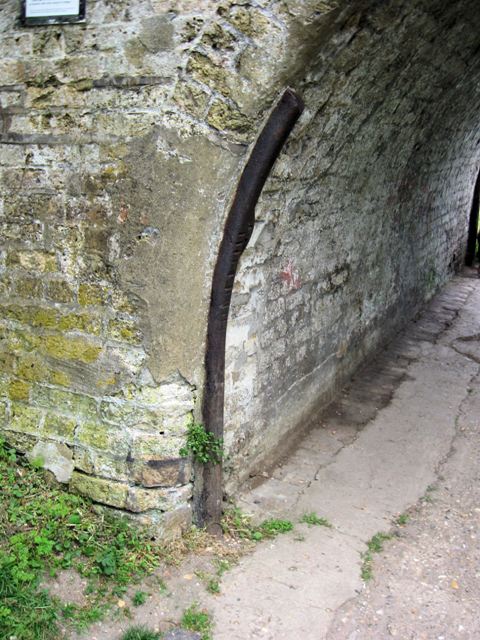
English: Iron Protector on Bridge No 130, Grand Union Canal. When barges were towed by horses there were places where the tow rope could rub against the arch of a bridge. If they had come against the brickwork the hawser would act like a saw, cutting into the brickwork. For this reason iron bars were mounted on the vulnerable brick corners to avoid damage to the bridge.
For more relevant pictures see 1462916. |
| Date | |
| Source | From geograph.org.uk |
| Author | Chris Reynolds |
| Attribution (required by the license) | Chris Reynolds / Iron Protector on Bridge No 130, Grand Union Canal / |
| Camera location | | View this and other nearby images on: OpenStreetMap |
|---|
_heading:22.00&language=en)
| Object location | | View this and other nearby images on: OpenStreetMap |
|---|
_heading:22.00&language=en)
Licensing
[edit]

|
This image was taken from the Geograph project collection. See this photograph's page on the Geograph website for the photographer's contact details. The copyright on this image is owned by Chris Reynolds and is licensed for reuse under the Creative Commons Attribution-ShareAlike 2.0 license.
|
This file is licensed under the Creative Commons Attribution-Share Alike 2.0 Generic license.
Attribution: Chris Reynolds
- You are free:
- to share – to copy, distribute and transmit the work
- to remix – to adapt the work
- Under the following conditions:
- attribution – You must give appropriate credit, provide a link to the license, and indicate if changes were made. You may do so in any reasonable manner, but not in any way that suggests the licensor endorses you or your use.
- share alike – If you remix, transform, or build upon the material, you must distribute your contributions under the same or compatible license as the original.
File history
Click on a date/time to view the file as it appeared at that time.
| Date/Time | Thumbnail | Dimensions | User | Comment | |
|---|---|---|---|---|---|
| current | 08:45, 2 March 2011 | | 480 × 640 (83 KB) | GeographBot (talk | contribs) | == {{int:filedesc}} == {{Information |description={{en|1=Iron Protector on Bridge No 130, Grand Union Canal When barges were towed by horses there were places where the tow rope could rub against the arch of a bridge. If they had come against the brickwo |
You cannot overwrite this file.
File usage on Commons
There are no pages that use this file.